Ranten geodata
Ranten (Styria) is a seat of a third-order administrative division; located in Austria in Europe/Vienna (GMT+2) time zone. With population of 621 people, there are 2064 cities with bigger population in this country. Compared to other cities in Austria, 75.1% of cities are located further ↑North; 63.3% of cities are located further →East and 92.4% of cities have lower elevation than Ranten. Note1


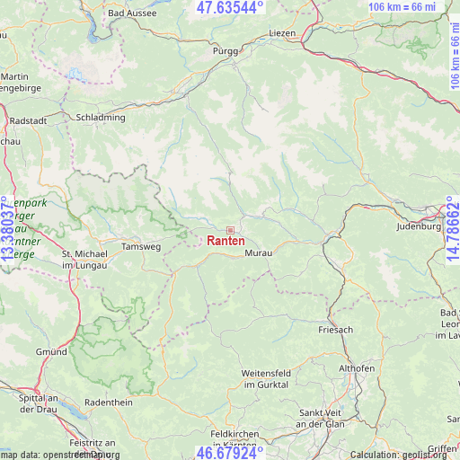
Ranten GPS coordinates[2]
47° 9' 34.164" North, 14° 5' 0.564" East
| Map corner | latitude | longitude |
|---|---|---|
| Upper-left | 47.63544°, | 13.38037° |
| Center: | 47.15949°, | 14.08349° |
| Lower-right: | 46.67924°, | 14.78662° |
| Map W x H: | 106.3×106.3 km | = 66.1×66.1mi |
| max Lat: | 48.98333° ⇑75.1% North |
| Ranten: | 47.15949° |
| min Lat: | ⇓24.9% South 46.48841° |
| min Long | Ranten | max Long |
| 9.57802° | 14.08349° | 17.1° |
| W 36.7%⇐ | ⇒63.3% E |
Elevation
Elevation of Ranten is 936 m = 3071 ft, and this is 430.5 m = 1412 ft above average elevation for this country.
| Max E: |
2140 m = 7021 ft | 7.6% |
| Ranten | 936 m 3071 ft | |
| Avg. | 505.5 m = 1658 ft | |
Min E: |
118 m = 387 ft | 92.4% |
See also: Austria elevation on elevation.city.
Geographical zone
Ranten is located in North temperate zone (between Tropic of Cancer and the Arctic Circle). Distance of this North polar circle is 2157.5 km =1340.6 mi to North.| Distance of | km | miles | from Ranten |
|---|---|---|---|
| North Pole | 4763.4 | 2959.8 | to North |
| Arctic Circle | 2157.5 | 1340.6 | to North |
| Tropic Cancer | 2637.7 | 1639 | to South |
| Equator | 5243.6 | 3258.2 | to South |


Nearby cities:
15 places around Ranten: (largest is in red/bold)
• Katsch an der Mur
14.8 km =9.2 mi,  95°
95°
• Krakaudorf
5.3 km =3.3 mi,  297°
297°
• Krakauhintermühlen
8 km =5 mi,  289°
289°
• Krakauschatten
9.2 km =5.7 mi, 286°
• Murau
8.5 km =5.3 mi,  129°
129°
• Oberwölz Stadt
15.8 km =9.8 mi,  72°
72°
• Sankt Georgen ob Murau
6.7 km =4.2 mi,  169°
169°
• Sankt Lorenzen ob Murau
7 km =4.3 mi, 173°
• Sankt Peter am Kammersberg
8.2 km =5.1 mi, 68°
• Schöder
2.9 km =1.8 mi,  25°
25°
• St. Ruprecht-Falkendorf
8.2 km =5.1 mi,  217°
217°
• Stadl an der Mur
12.2 km =7.6 mi,  226°
226°
• Triebendorf
12.3 km =7.6 mi,  112°
112°
• Vorstadt
15.8 km =9.8 mi, 72°
• Winklern bei Oberwölz
12.2 km =7.6 mi, 68°
Sources, notices
• [Note1] Compared only with cities in Austria existing in our database
• [Src1] Map data: © OpenStreetMap contributors (CC-BY-SA)
• [Src2] Other city data from geonames.org with taken over terms of usage.
• [Src3] Geographical zone / Annual Mean Temperature by Robert A. Rohde @ Wikipedia
