Helfenstein geodata
Helfenstein (Tyrol) is a populated place; located in Austria in Europe/Vienna (GMT+2) time zone. With population of 511 people, there are 2465 cities with bigger population in this country. Compared to other cities in Austria, 63.4% of cities are located further ↑North; 89.6% of cities are located further →East and 63.2% of cities have lower elevation than Helfenstein. Note1
Administrative division(s):
- Level 1: Tyrol
- Level 2: Politischer Bezirk Schwaz
- Level 3: Hart im Zillertal


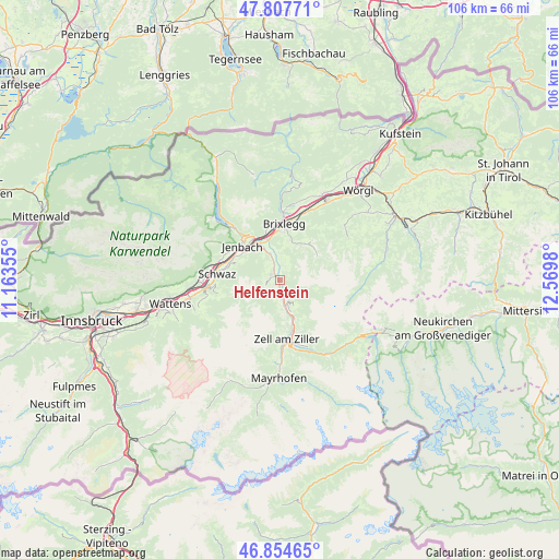
Helfenstein GPS coordinates[2]
47° 19' 59.988" North, 11° 52' 0.012" East
| Map corner | latitude | longitude |
|---|---|---|
| Upper-left | 47.80771°, | 11.16355° |
| Center: | 47.33333°, | 11.86667° |
| Lower-right: | 46.85465°, | 12.5698° |
| Map W x H: | 106×106 km | = 65.9×65.9mi |
| max Lat: | 48.98333° ⇑63.4% North |
| Helfenstein: | 47.33333° |
| min Lat: | ⇓36.6% South 46.48841° |
| min Long | Helfenstein | max Long |
| 9.57802° | 11.86667° | 17.1° |
| W 10.4%⇐ | ⇒89.6% E |
Elevation
Elevation of Helfenstein is 540 m = 1772 ft, and this is 34.5 m = 113 ft above average elevation for this country.
| Max E: |
2140 m = 7021 ft | 36.8% |
| Helfenstein | 540 m 1772 ft | |
| Avg. | 505.5 m = 1658 ft | |
Min E: |
118 m = 387 ft | 63.2% |
See also: Austria elevation on elevation.city.
Geographical zone
Helfenstein is located in North temperate zone (between Tropic of Cancer and the Arctic Circle). Distance of this North polar circle is 2138.2 km =1328.6 mi to North.| Distance of | km | miles | from Helfenstein |
|---|---|---|---|
| North Pole | 4744.1 | 2947.8 | to North |
| Arctic Circle | 2138.2 | 1328.6 | to North |
| Tropic Cancer | 2657.1 | 1651 | to South |
| Equator | 5263 | 3270.3 | to South |


Nearby cities:
15 places around Helfenstein: (largest is in red/bold)
• Aschau
7.8 km =4.8 mi,  161°
161°
• Aschau im Zillertal
7.8 km =4.8 mi, 163°
• Bruck am Ziller
6.4 km =4 mi,  349°
349°
• Finsing
0.9 km =0.6 mi,  213°
213°
• Fügen
2 km =1.2 mi,  319°
319°
• Fügenberg
2.8 km =1.7 mi, 318°
• Hart im Zillertal
2 km =1.2 mi,  355°
355°
• Kaltenbach
5.6 km =3.5 mi,  180°
180°
• Kapfing
1.3 km =0.8 mi,  270°
270°
• Pankrazberg
4.2 km =2.6 mi,  243°
243°
• Ried im Zillertal
3.7 km =2.3 mi, 180°
• Schlitters
5.6 km =3.5 mi,  338°
338°
• Stumm
5 km =3.1 mi, 161°
• Stummerberg
6.7 km =4.2 mi,  145°
145°
• Uderns
1.9 km =1.2 mi, 180°
Sources, notices
• [Note1] Compared only with cities in Austria existing in our database
• [Src1] Map data: © OpenStreetMap contributors (CC-BY-SA)
• [Src2] Other city data from geonames.org with taken over terms of usage.
• [Src3] Geographical zone / Annual Mean Temperature by Robert A. Rohde @ Wikipedia
