Fügen geodata
Fügen (Tyrol) is a seat of a third-order administrative division; located in Austria in Europe/Vienna (GMT+2) time zone. With population of 2,617 people, there are 450 cities with bigger population in this country. Compared to other cities in Austria, 62.9% of cities are located further ↑North; 89.9% of cities are located further →East and 63.8% of cities have lower elevation than Fügen. Note1


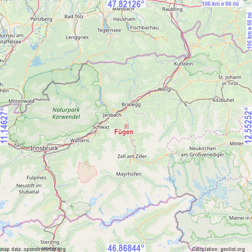
Fügen GPS coordinates[2]
47° 20' 49.2" North, 11° 50' 57.804" East
| Map corner | latitude | longitude |
|---|---|---|
| Upper-left | 47.82126°, | 11.14627° |
| Center: | 47.347°, | 11.84939° |
| Lower-right: | 46.86844°, | 12.55252° |
| Map W x H: | 105.9×105.9 km | = 65.8×65.8mi |
| max Lat: | 48.98333° ⇑62.9% North |
| Fügen: | 47.347° |
| min Lat: | ⇓37.1% South 46.48841° |
| min Long | Fügen | max Long |
| 9.57802° | 11.84939° | 17.1° |
| W 10.1%⇐ | ⇒89.9% E |
Elevation
Elevation of Fügen is 544 m = 1785 ft, and this is 38.5 m = 126 ft above average elevation for this country.
| Max E: |
2140 m = 7021 ft | 36.2% |
| Fügen | 544 m 1785 ft | |
| Avg. | 505.5 m = 1658 ft | |
Min E: |
118 m = 387 ft | 63.8% |
See also: Austria elevation on elevation.city.
Geographical zone
Fügen is located in North temperate zone (between Tropic of Cancer and the Arctic Circle). Distance of this North polar circle is 2136.7 km =1327.7 mi to North.| Distance of | km | miles | from Fügen |
|---|---|---|---|
| North Pole | 4742.6 | 2946.9 | to North |
| Arctic Circle | 2136.7 | 1327.7 | to North |
| Tropic Cancer | 2658.6 | 1652 | to South |
| Equator | 5264.5 | 3271.2 | to South |


Nearby cities:
15 places around Fügen: (largest is in red/bold)
• Bruck am Ziller
4.8 km =3 mi,  1°
1°
• Finsing
2.4 km =1.5 mi,  160°
160°
• Fügenberg
0.8 km =0.5 mi,  314°
314°
• Gallzein
6.3 km =3.9 mi,  291°
291°
• Hart im Zillertal
1.2 km =0.7 mi,  68°
68°
• Helfenstein
2 km =1.2 mi,  139°
139°
• Kaltenbach
7.2 km =4.5 mi,  169°
169°
• Kapfing
1.5 km =0.9 mi,  178°
178°
• Pankrazberg
4.2 km =2.6 mi,  216°
216°
• Ried im Zillertal
5.4 km =3.4 mi, 166°
• Schlitters
3.8 km =2.4 mi,  347°
347°
• Strass im Zillertal
5.8 km =3.6 mi,  337°
337°
• Stumm
6.9 km =4.3 mi, 155°
• Uderns
3.6 km =2.2 mi, 158°
• Wiesing
7.5 km =4.7 mi,  328°
328°
Sources, notices
• [Note1] Compared only with cities in Austria existing in our database
• [Src1] Map data: © OpenStreetMap contributors (CC-BY-SA)
• [Src2] Other city data from geonames.org with taken over terms of usage.
• [Src3] Geographical zone / Annual Mean Temperature by Robert A. Rohde @ Wikipedia
