Grafenegg geodata
Grafenegg (Lower Austria) is a seat of a third-order administrative division; located in Austria in Europe/Vienna (GMT+2) time zone. With population of 45 people, there are 2941 cities with bigger population in this country. Compared to other cities in Austria, 91.8% of cities are located further ↓South; 73.3% of cities are located further ←West and 92.4% of cities have higher elevation than Grafenegg. Note1
Administrative division(s):
- Level 1: Lower Austria
- Level 2: Politischer Bezirk Krems
- Level 3: Grafenegg


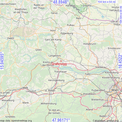
Grafenegg GPS coordinates[2]
48° 25' 49.44" North, 15° 44' 56.652" East
| Map corner | latitude | longitude |
|---|---|---|
| Upper-left | 48.8948°, | 15.04595° |
| Center: | 48.4304°, | 15.74907° |
| Lower-right: | 47.96171°, | 16.4522° |
| Map W x H: | 103.7×103.7 km | = 64.4×64.4mi |
| max Lat: | 48.98333° ⇑8.2% North |
| Grafenegg: | 48.4304° |
| min Lat: | ⇓91.8% South 46.48841° |
| min Long | Grafenegg | max Long |
| 9.57802° | 15.74907° | 17.1° |
| W 73.3%⇐ | ⇒26.7% E |
Elevation
Elevation of Grafenegg is 196 m = 643 ft, and this is 309.5 m = 1015 ft below average elevation for this country.
| Max E: |
2140 m = 7021 ft | 92.4% |
| Avg. | 505.5 m = 1658 ft | |
| Grafenegg | 196 m = 643 ft | |
Min E: |
118 m = 387 ft | 7.6% |
See also: Austria elevation on elevation.city.
Geographical zone
Grafenegg is located in North temperate zone (between Tropic of Cancer and the Arctic Circle). Distance of this North polar circle is 2016.2 km =1252.8 mi to North.| Distance of | km | miles | from Grafenegg |
|---|---|---|---|
| North Pole | 4622.1 | 2872 | to North |
| Arctic Circle | 2016.2 | 1252.8 | to North |
| Tropic Cancer | 2779 | 1726.8 | to South |
| Equator | 5385 | 3346.1 | to South |


Nearby cities:
15 places around Grafenegg: (largest is in red/bold)
• Brunn im Felde
3.7 km =2.3 mi,  267°
267°
• Engabrunn
2.2 km =1.4 mi,  1°
1°
• Etsdorf am Kamp
1.2 km =0.7 mi,  285°
285°
• Fels am Wagram
5 km =3.1 mi,  86°
86°
• Feuersbrunn
2.5 km =1.6 mi,  82°
82°
• Gedersdorf
4.5 km =2.8 mi, 273°
• Gobelsburg
4.9 km =3 mi,  313°
313°
• Grafenwörth
3.3 km =2.1 mi,  139°
139°
• Hadersdorf am Kamp
3.2 km =2 mi, 312°
• Langenlois
7.3 km =4.5 mi,  303°
303°
• Rohrendorf bei Krems
6.9 km =4.3 mi,  259°
259°
• Strass
4.2 km =2.6 mi,  343°
343°
• Theiss
5.6 km =3.5 mi,  230°
230°
• Wagram ob der Traisen
8 km =5 mi,  199°
199°
• Zöbing
7.6 km =4.7 mi,  320°
320°
Sources, notices
• [Note1] Compared only with cities in Austria existing in our database
• [Src1] Map data: © OpenStreetMap contributors (CC-BY-SA)
• [Src2] Other city data from geonames.org with taken over terms of usage.
• [Src3] Geographical zone / Annual Mean Temperature by Robert A. Rohde @ Wikipedia
