Gobelsburg geodata
Gobelsburg (Lower Austria) is a populated place; located in Austria in Europe/Vienna (GMT+2) time zone. With population of 845 people, there are 1529 cities with bigger population in this country. Compared to other cities in Austria, 93% of cities are located further ↓South; 72.2% of cities are located further ←West and 91.6% of cities have higher elevation than Gobelsburg. Note1
Administrative division(s):
- Level 1: Lower Austria
- Level 2: Politischer Bezirk Krems
- Level 3: Langenlois


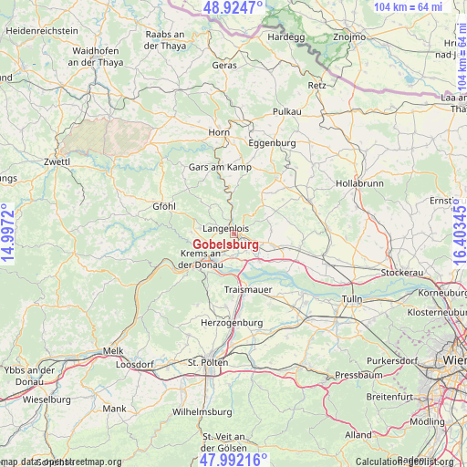
Gobelsburg GPS coordinates[2]
48° 27' 38.052" North, 15° 42' 1.152" East
| Map corner | latitude | longitude |
|---|---|---|
| Upper-left | 48.9247°, | 14.9972° |
| Center: | 48.46057°, | 15.70032° |
| Lower-right: | 47.99216°, | 16.40345° |
| Map W x H: | 103.7×103.7 km | = 64.4×64.4mi |
| max Lat: | 48.98333° ⇑7% North |
| Gobelsburg: | 48.46057° |
| min Lat: | ⇓93% South 46.48841° |
| min Long | Gobelsburg | max Long |
| 9.57802° | 15.70032° | 17.1° |
| W 72.2%⇐ | ⇒27.8% E |
Elevation
Elevation of Gobelsburg is 204 m = 669 ft, and this is 301.5 m = 989 ft below average elevation for this country.
| Max E: |
2140 m = 7021 ft | 91.6% |
| Avg. | 505.5 m = 1658 ft | |
| Gobelsburg | 204 m = 669 ft | |
Min E: |
118 m = 387 ft | 8.4% |
See also: Austria elevation on elevation.city.
Geographical zone
Gobelsburg is located in North temperate zone (between Tropic of Cancer and the Arctic Circle). Distance of this North polar circle is 2012.9 km =1250.8 mi to North.| Distance of | km | miles | from Gobelsburg |
|---|---|---|---|
| North Pole | 4618.8 | 2870 | to North |
| Arctic Circle | 2012.9 | 1250.8 | to North |
| Tropic Cancer | 2782.4 | 1728.9 | to South |
| Equator | 5388.3 | 3348.1 | to South |


Nearby cities:
15 places around Gobelsburg: (largest is in red/bold)
• Brunn im Felde
3.5 km =2.2 mi,  182°
182°
• Engabrunn
3.8 km =2.4 mi,  107°
107°
• Etsdorf am Kamp
3.9 km =2.4 mi,  141°
141°
• Feuersbrunn
6.8 km =4.2 mi,  116°
116°
• Gedersdorf
3.2 km =2 mi,  195°
195°
• Gneixendorf
6.6 km =4.1 mi,  247°
247°
• Grafenegg
4.9 km =3 mi,  133°
133°
• Hadersdorf am Kamp
1.7 km =1.1 mi, 134°
• Landersdorf
6.9 km =4.3 mi,  225°
225°
• Langenlois
2.6 km =1.6 mi,  285°
285°
• Rohrendorf bei Krems
5.6 km =3.5 mi,  214°
214°
• Schönberg
6.2 km =3.9 mi,  359°
359°
• Strass
2.5 km =1.6 mi,  74°
74°
• Theiss
7 km =4.3 mi,  185°
185°
• Zöbing
2.8 km =1.7 mi,  333°
333°
Sources, notices
• [Note1] Compared only with cities in Austria existing in our database
• [Src1] Map data: © OpenStreetMap contributors (CC-BY-SA)
• [Src2] Other city data from geonames.org with taken over terms of usage.
• [Src3] Geographical zone / Annual Mean Temperature by Robert A. Rohde @ Wikipedia
