Gmünd geodata
Gmünd (Lower Austria) is a seat of a third-order administrative division; located in Austria in Europe/Vienna (GMT+2) time zone. With population of 4,674 people, there are 209 cities with bigger population in this country. Compared to other cities in Austria, 99.1% of cities are located further ↓South; 54% of cities are located further ←West and 56.8% of cities have lower elevation than Gmünd. Note1


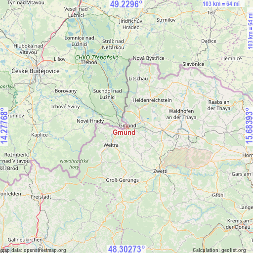
Gmünd GPS coordinates[2]
48° 46' 5.88" North, 14° 58' 50.88" East
| Map corner | latitude | longitude |
|---|---|---|
| Upper-left | 49.2296°, | 14.27768° |
| Center: | 48.7683°, | 14.9808° |
| Lower-right: | 48.30273°, | 15.68393° |
| Map W x H: | 103.1×103.1 km | = 64.1×64.1mi |
| max Lat: | 48.98333° ⇑0.9% North |
| Gmünd: | 48.7683° |
| min Lat: | ⇓99.1% South 46.48841° |
| min Long | Gmünd | max Long |
| 9.57802° | 14.9808° | 17.1° |
| W 54%⇐ | ⇒46% E |
Elevation
Elevation of Gmünd is 497 m = 1631 ft, and this is 8.5 m = 28 ft below average elevation for this country.
| Max E: |
2140 m = 7021 ft | 43.2% |
| Avg. | 505.5 m = 1658 ft | |
| Gmünd | 497 m = 1631 ft | |
Min E: |
118 m = 387 ft | 56.8% |
See also: Austria elevation on elevation.city.
Geographical zone
Gmünd is located in North temperate zone (between Tropic of Cancer and the Arctic Circle). Distance of this North polar circle is 1978.6 km =1229.4 mi to North.| Distance of | km | miles | from Gmünd |
|---|---|---|---|
| North Pole | 4584.5 | 2848.7 | to North |
| Arctic Circle | 1978.6 | 1229.4 | to North |
| Tropic Cancer | 2816.6 | 1750.2 | to South |
| Equator | 5422.5 | 3369.4 | to South |


Nearby cities:
15 places around Gmünd: (largest is in red/bold)
• Altnagelberg
9.2 km =5.7 mi,  8°
8°
• Amaliendorf
10.4 km =6.5 mi,  46°
46°
• Dietmanns
5.2 km =3.2 mi,  221°
221°
• Echsenbach
18.2 km =11.3 mi,  108°
108°
• Eisgarn
18.8 km =11.7 mi,  28°
28°
• Grosspertholz
19.3 km =12 mi, 216°
• Heidenreichstein
14.8 km =9.2 mi,  42°
42°
• Hirschbach
10.9 km =6.8 mi,  104°
104°
• Hoheneich
3.5 km =2.2 mi,  83°
83°
• Kirchberg am Walde
9.2 km =5.7 mi,  121°
121°
• Schrems
6.5 km =4 mi, 75°
• Schweiggers
12.9 km =8 mi,  150°
150°
• Vitis
14.8 km =9.2 mi,  93°
93°
• Waldenstein
5.1 km =3.2 mi, 151°
• Weitra
10.4 km =6.5 mi, 223°
Sources, notices
• [Note1] Compared only with cities in Austria existing in our database
• [Src1] Map data: © OpenStreetMap contributors (CC-BY-SA)
• [Src2] Other city data from geonames.org with taken over terms of usage.
• [Src3] Geographical zone / Annual Mean Temperature by Robert A. Rohde @ Wikipedia
