Feistritz bei Knittelfeld geodata
Feistritz bei Knittelfeld (Styria) is a seat of a third-order administrative division; located in Austria in Europe/Vienna (GMT+2) time zone. With population of 614 people, there are 2083 cities with bigger population in this country. Compared to other cities in Austria, 67.9% of cities are located further ↑North; 53.2% of cities are located further ←West and 74.1% of cities have lower elevation than Feistritz bei Knittelfeld. Note1
Administrative division(s):
- Level 1: Styria
- Level 2: Politischer Bezirk Murtal
- Level 3: Sankt Marein-Feistritz
Current local time in Feistritz bei Knittelfeld:
11:56 PM, FridayDifference from your time zone: hours


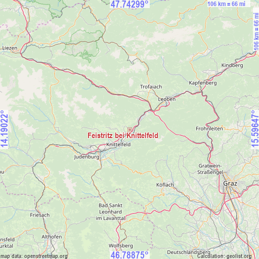
Feistritz bei Knittelfeld GPS coordinates[2]
47° 16' 4.872" North, 14° 53' 36.024" East
| Map corner | latitude | longitude |
|---|---|---|
| Upper-left | 47.74299°, | 14.19022° |
| Center: | 47.26802°, | 14.89334° |
| Lower-right: | 46.78875°, | 15.59647° |
| Map W x H: | 106.1×106.1 km | = 65.9×65.9mi |
| max Lat: | 48.98333° ⇑67.9% North |
| Feistritz bei Knittelfeld: | 47.26802° |
| min Lat: | ⇓32.1% South 46.48841° |
| min Long | Feistritz bei K | max Long |
| 9.57802° | 14.89334° | 17.1° |
| W 53.2%⇐ | ⇒46.8% E |
Elevation
Elevation of Feistritz bei Knittelfeld is 638 m = 2093 ft, and this is 132.5 m = 435 ft above average elevation for this country.
| Max E: |
2140 m = 7021 ft | 25.9% |
| Feistritz bei Knittelfeld | 638 m 2093 ft | |
| Avg. | 505.5 m = 1658 ft | |
Min E: |
118 m = 387 ft | 74.1% |
See also: Austria elevation on elevation.city.
Geographical zone
Feistritz bei Knittelfeld is located in North temperate zone (between Tropic of Cancer and the Arctic Circle). Distance of this North polar circle is 2145.5 km =1333.2 mi to North.| Distance of | km | miles | from Feistritz bei Knittelfeld |
|---|---|---|---|
| North Pole | 4751.4 | 2952.4 | to North |
| Arctic Circle | 2145.5 | 1333.2 | to North |
| Tropic Cancer | 2649.8 | 1646.5 | to South |
| Equator | 5255.7 | 3265.7 | to South |


Nearby cities:
15 places around Feistritz bei Knittelfeld: (largest is in red/bold)
• Apfelberg
8.8 km =5.5 mi,  210°
210°
• Flatschach
12.2 km =7.6 mi,  242°
242°
• Großlobming
11.8 km =7.3 mi,  216°
216°
• Knittelfeld
8.1 km =5 mi,  225°
225°
• Kobenz
3.8 km =2.4 mi, 238°
• Kraubath an der Mur
4.7 km =2.9 mi,  40°
40°
• Landschach
8.8 km =5.5 mi, 210°
• Rachau
5.7 km =3.5 mi,  174°
174°
• Sankt Lorenzen bei Knittelfeld
1.9 km =1.2 mi,  175°
175°
• Sankt Marein bei Knittelfeld
2.5 km =1.6 mi,  285°
285°
• Sankt Margarethen bei Knittelfeld
6.1 km =3.8 mi,  199°
199°
• Sankt Michael in Obersteiermark
12.2 km =7.6 mi,  50°
50°
• Sankt Stefan ob Leoben
8.4 km =5.2 mi, 49°
• Seckau
8.3 km =5.2 mi,  268°
268°
• Spielberg bei Knittelfeld
10.1 km =6.3 mi, 235°
Sources, notices
• [Note1] Compared only with cities in Austria existing in our database
• [Src1] Map data: © OpenStreetMap contributors (CC-BY-SA)
• [Src2] Other city data from geonames.org with taken over terms of usage.
• [Src3] Geographical zone / Annual Mean Temperature by Robert A. Rohde @ Wikipedia
