Gerlosberg geodata
Gerlosberg (Tyrol) is a seat of a third-order administrative division; located in Austria in Europe/Vienna (GMT+2) time zone. With population of 465 people, there are 2544 cities with bigger population in this country. Compared to other cities in Austria, 71.6% of cities are located further ↑North; 88.8% of cities are located further →East and 91.5% of cities have lower elevation than Gerlosberg. Note1


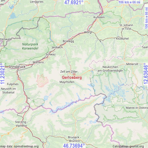
Gerlosberg GPS coordinates[2]
47° 13' 0.012" North, 11° 55' 59.988" East
| Map corner | latitude | longitude |
|---|---|---|
| Upper-left | 47.6921°, | 11.23021° |
| Center: | 47.21667°, | 11.93333° |
| Lower-right: | 46.73694°, | 12.63646° |
| Map W x H: | 106.2×106.2 km | = 66×66mi |
| max Lat: | 48.98333° ⇑71.6% North |
| Gerlosberg: | 47.21667° |
| min Lat: | ⇓28.4% South 46.48841° |
| min Long | Gerlosberg | max Long |
| 9.57802° | 11.93333° | 17.1° |
| W 11.2%⇐ | ⇒88.8% E |
Elevation
Elevation of Gerlosberg is 911 m = 2989 ft, and this is 405.5 m = 1330 ft above average elevation for this country.
| Max E: |
2140 m = 7021 ft | 8.5% |
| Gerlosberg | 911 m 2989 ft | |
| Avg. | 505.5 m = 1658 ft | |
Min E: |
118 m = 387 ft | 91.5% |
See also: Austria elevation on elevation.city.
Geographical zone
Gerlosberg is located in North temperate zone (between Tropic of Cancer and the Arctic Circle). Distance of this North polar circle is 2151.2 km =1336.7 mi to North.| Distance of | km | miles | from Gerlosberg |
|---|---|---|---|
| North Pole | 4757.1 | 2955.9 | to North |
| Arctic Circle | 2151.2 | 1336.7 | to North |
| Tropic Cancer | 2644.1 | 1643 | to South |
| Equator | 5250 | 3262.2 | to South |


Nearby cities:
15 places around Gerlosberg: (largest is in red/bold)
• Aschau
6.1 km =3.8 mi,  335°
335°
• Aschau im Zillertal
6.2 km =3.9 mi,  332°
332°
• Gerlos
7.4 km =4.6 mi,  83°
83°
• Hainzenberg
2.5 km =1.6 mi,  273°
273°
• Hippach
5.3 km =3.3 mi,  255°
255°
• Hippach-Schwendberg
6.4 km =4 mi, 256°
• Laimach
5 km =3.1 mi, 270°
• Mayrhofen
7.5 km =4.7 mi,  222°
222°
• Ramsau im Zillertal
4.6 km =2.9 mi,  251°
251°
• Rohrberg
2.2 km =1.4 mi, 325°
• Schwendau
6 km =3.7 mi, 249°
• Stumm
8.9 km =5.5 mi, 337°
• Stummerberg
7.5 km =4.7 mi,  350°
350°
• Zell am Ziller
4.2 km =2.6 mi,  296°
296°
• Zellberg
6.6 km =4.1 mi,  286°
286°
Sources, notices
• [Note1] Compared only with cities in Austria existing in our database
• [Src1] Map data: © OpenStreetMap contributors (CC-BY-SA)
• [Src2] Other city data from geonames.org with taken over terms of usage.
• [Src3] Geographical zone / Annual Mean Temperature by Robert A. Rohde @ Wikipedia
