Hippach-Schwendberg geodata
Hippach-Schwendberg (Tyrol) is a populated place; located in Austria in Europe/Vienna (GMT+2) time zone. With population of 690 people, there are 1882 cities with bigger population in this country. Compared to other cities in Austria, 72.2% of cities are located further ↑North; 89.8% of cities are located further →East and 95.2% of cities have lower elevation than Hippach-Schwendberg. Note1


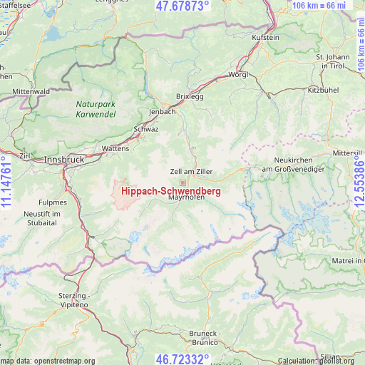
Hippach-Schwendberg GPS coordinates[2]
47° 12' 11.448" North, 11° 51' 2.628" East
| Map corner | latitude | longitude |
|---|---|---|
| Upper-left | 47.67873°, | 11.14761° |
| Center: | 47.20318°, | 11.85073° |
| Lower-right: | 46.72332°, | 12.55386° |
| Map W x H: | 106.2×106.2 km | = 66×66mi |
| max Lat: | 48.98333° ⇑72.2% North |
| Hippach-Schwendberg: | 47.20318° |
| min Lat: | ⇓27.8% South 46.48841° |
| min Long | Hippach-Schwend | max Long |
| 9.57802° | 11.85073° | 17.1° |
| W 10.2%⇐ | ⇒89.8% E |
Elevation
Elevation of Hippach-Schwendberg is 1029 m = 3376 ft, and this is 523.5 m = 1718 ft above average elevation for this country.
| Max E: |
2140 m = 7021 ft | 4.8% |
| Hippach-Schwendberg | 1029 m 3376 ft | |
| Avg. | 505.5 m = 1658 ft | |
Min E: |
118 m = 387 ft | 95.2% |
See also: Austria elevation on elevation.city.
Geographical zone
Hippach-Schwendberg is located in North temperate zone (between Tropic of Cancer and the Arctic Circle). Distance of this North polar circle is 2152.7 km =1337.6 mi to North.| Distance of | km | miles | from Hippach-Schwendberg |
|---|---|---|---|
| North Pole | 4758.6 | 2956.9 | to North |
| Arctic Circle | 2152.7 | 1337.6 | to North |
| Tropic Cancer | 2642.6 | 1642 | to South |
| Equator | 5248.5 | 3261.3 | to South |


Nearby cities:
15 places around Hippach-Schwendberg: (largest is in red/bold)
• Aschau
8 km =5 mi,  27°
27°
• Aschau im Zillertal
7.8 km =4.8 mi, 25°
• Finkenberg
6 km =3.7 mi,  201°
201°
• Gerlosberg
6.4 km =4 mi,  76°
76°
• Hainzenberg
4.1 km =2.5 mi,  66°
66°
• Hippach
1.1 km =0.7 mi, 83°
• Kaltenbach
9 km =5.6 mi,  7°
7°
• Laimach
1.9 km =1.2 mi,  38°
38°
• Mayrhofen
4.2 km =2.6 mi,  163°
163°
• Ramsau im Zillertal
1.9 km =1.2 mi,  87°
87°
• Rohrberg
6 km =3.7 mi,  56°
56°
• Schwendau
0.9 km =0.6 mi,  135°
135°
• Stumm
10.1 km =6.3 mi,  15°
15°
• Zell am Ziller
4.2 km =2.6 mi, 36°
• Zellberg
3.4 km =2.1 mi,  359°
359°
Sources, notices
• [Note1] Compared only with cities in Austria existing in our database
• [Src1] Map data: © OpenStreetMap contributors (CC-BY-SA)
• [Src2] Other city data from geonames.org with taken over terms of usage.
• [Src3] Geographical zone / Annual Mean Temperature by Robert A. Rohde @ Wikipedia
