Brand geodata
Brand (Vorarlberg) is a seat of a third-order administrative division; located in Austria in Europe/Vienna (GMT+2) time zone. With population of 719 people, there are 1807 cities with bigger population in this country. Compared to other cities in Austria, 78.8% of cities are located further ↑North; 98.8% of cities are located further →East and 95.3% of cities have lower elevation than Brand. Note1


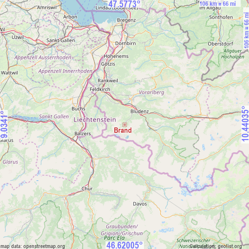
Brand GPS coordinates[2]
47° 6' 2.988" North, 9° 44' 13.992" East
| Map corner | latitude | longitude |
|---|---|---|
| Upper-left | 47.5773°, | 9.0341° |
| Center: | 47.10083°, | 9.73722° |
| Lower-right: | 46.62005°, | 10.44035° |
| Map W x H: | 106.4×106.4 km | = 66.1×66.1mi |
| max Lat: | 48.98333° ⇑78.8% North |
| Brand: | 47.10083° |
| min Lat: | ⇓21.2% South 46.48841° |
| min Long | Brand | max Long |
| 9.57802° | 9.73722° | 17.1° |
| W 1.2%⇐ | ⇒98.8% E |
Elevation
Elevation of Brand is 1035 m = 3396 ft, and this is 529.5 m = 1737 ft above average elevation for this country.
| Max E: |
2140 m = 7021 ft | 4.7% |
| Brand | 1035 m 3396 ft | |
| Avg. | 505.5 m = 1658 ft | |
Min E: |
118 m = 387 ft | 95.3% |
See also: Austria elevation on elevation.city.
Geographical zone
Brand is located in North temperate zone (between Tropic of Cancer and the Arctic Circle). Distance of this North polar circle is 2164.1 km =1344.7 mi to North.| Distance of | km | miles | from Brand |
|---|---|---|---|
| North Pole | 4769.9 | 2963.9 | to North |
| Arctic Circle | 2164.1 | 1344.7 | to North |
| Tropic Cancer | 2631.2 | 1635 | to South |
| Equator | 5237.1 | 3254.2 | to South |


Nearby cities:
15 places around Brand: (largest is in red/bold)
• Beschling
11 km =6.8 mi,  337°
337°
• Bludenz
8.8 km =5.5 mi,  47°
47°
• Bludesch
11 km =6.8 mi,  358°
358°
• Bürs
7.2 km =4.5 mi,  41°
41°
• Bürserberg
5.9 km =3.7 mi,  30°
30°
• Lorüns
9.3 km =5.8 mi,  67°
67°
• Ludesch
11.6 km =7.2 mi,  17°
17°
• Nenzing
9.6 km =6 mi,  345°
345°
• Nüziders
8.7 km =5.4 mi, 32°
• Sankt Anton im Montafon
10 km =6.2 mi,  79°
79°
• Schlins
11.4 km =7.1 mi, 345°
• Stallehr
9.3 km =5.8 mi, 67°
• Thüringen
11.2 km =7 mi,  11°
11°
• Tschagguns
12.5 km =7.8 mi,  98°
98°
• Vandans
9.7 km =6 mi,  93°
93°
Sources, notices
• [Note1] Compared only with cities in Austria existing in our database
• [Src1] Map data: © OpenStreetMap contributors (CC-BY-SA)
• [Src2] Other city data from geonames.org with taken over terms of usage.
• [Src3] Geographical zone / Annual Mean Temperature by Robert A. Rohde @ Wikipedia
