Stoneville geodata
Stoneville (Western Australia) is a populated place; located in Australia in Australia/Perth (GMT+8) time zone. With population of 2,841 people, there are 2354 cities with bigger population in this country. Compared to other cities in Australia, 71% of cities are located further ↓South; 89.1% of cities are located further →East and 88.9% of cities have lower elevation than Stoneville. Note1


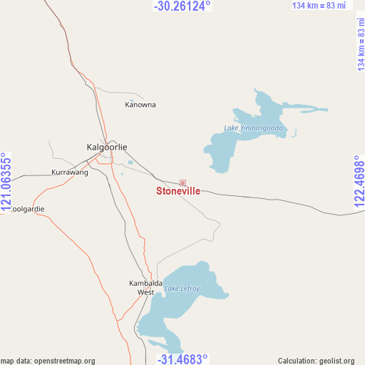
Stoneville GPS coordinates[2]
30° 52' 0.012" South, 121° 46' 0.012" East
| Map corner | latitude | longitude |
|---|---|---|
| Upper-left | -30.26124°, | 121.06355° |
| Center: | -30.86667°, | 121.76667° |
| Lower-right: | -31.4683°, | 122.4698° |
| Map W x H: | 134.2×134.2 km | = 83.4×83.4mi |
| max Lat: | -10.58257° ⇑29% North |
| Stoneville: | -30.86667° |
| min Lat: | ⇓71% South -43.31423° |
| min Long | Stoneville | max Long |
| 113.53327° | 121.76667° | 153.61246° |
| W 10.9%⇐ | ⇒89.1% E |
Elevation
Elevation of Stoneville is 345 m = 1132 ft, and this is 223 m = 732 ft above average elevation for this country.
| Max E: |
1715 m = 5627 ft | 11.1% |
| Stoneville | 345 m 1132 ft | |
| Avg. | 122 m = 400 ft | |
Min E: |
-2 m = -7 ft | 88.9% |
See also: Australia elevation on elevation.city.
Geographical zone
Stoneville is located in South temperate zone (between Tropic of Capricorn and the Antarctic Circle). Distance of this Southern Tropic circle is 826.1 km =513.3 mi to North.| Distance of | km | miles | from Stoneville |
|---|---|---|---|
| Equator | 3432.1 | 2132.6 | to North |
| Tropic Capricorn | 826.1 | 513.3 | to North |
| Antarctic Circle | 3969.1 | 2466.3 | to South |
| South Pole | 6575 | 4085.5 | to South |


Nearby cities:
15 places around Stoneville: (largest is in red/bold)
• Boulder
27.9 km =17.3 mi,  289°
289°
• Broadwood
31 km =19.3 mi, 285°
• Coolgardie
58.3 km =36.2 mi,  260°
260°
• Hannans
34 km =21.1 mi,  298°
298°
• Kalgoorlie
31 km =19.3 mi, 295°
• Kambalda East
38.8 km =24.1 mi,  193°
193°
• Kambalda West
39.4 km =24.5 mi,  199°
199°
• Lamington
32.6 km =20.3 mi, 296°
• Leonora
224.3 km =139.4 mi,  349°
349°
• Norseman
148 km =92 mi,  179°
179°
• Piccadilly
32 km =19.9 mi, 295°
• Somerville
31.7 km =19.7 mi, 289°
• South Kalgoorlie
30.2 km =18.8 mi, 291°
• Victory Heights
29.7 km =18.5 mi, 289°
• West Lamington
32.8 km =20.4 mi, 293°
Sources, notices
• [Note1] Compared only with cities in Australia existing in our database
• [Src1] Map data: © OpenStreetMap contributors (CC-BY-SA)
• [Src2] Other city data from geonames.org with taken over terms of usage.
• [Src3] Geographical zone / Annual Mean Temperature by Robert A. Rohde @ Wikipedia
