Norseman geodata
Norseman (Western Australia) is a populated place; located in Australia in Australia/Perth (GMT+8) time zone. With population of 640 people, there are 4472 cities with bigger population in this country. Compared to other cities in Australia, 62.8% of cities are located further ↓South; 89% of cities are located further →East and 86.9% of cities have lower elevation than Norseman. Note1


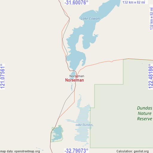
Norseman GPS coordinates[2]
32° 11' 51.684" South, 121° 46' 43.428" East
| Map corner | latitude | longitude |
|---|---|---|
| Upper-left | -31.60076°, | 121.07561° |
| Center: | -32.19769°, | 121.77873° |
| Lower-right: | -32.79073°, | 122.48186° |
| Map W x H: | 132.3×132.3 km | = 82.2×82.2mi |
| max Lat: | -10.58257° ⇑37.2% North |
| Norseman: | -32.19769° |
| min Lat: | ⇓62.8% South -43.31423° |
| min Long | Norseman | max Long |
| 113.53327° | 121.77873° | 153.61246° |
| W 11%⇐ | ⇒89% E |
Elevation
Elevation of Norseman is 284 m = 932 ft, and this is 162 m = 531 ft above average elevation for this country.
| Max E: |
1715 m = 5627 ft | 13.1% |
| Norseman | 284 m 932 ft | |
| Avg. | 122 m = 400 ft | |
Min E: |
-2 m = -7 ft | 86.9% |
See also: Australia elevation on elevation.city.
Geographical zone
Norseman is located in South temperate zone (between Tropic of Capricorn and the Antarctic Circle). Distance of this Southern Tropic circle is 974.1 km =605.3 mi to North.| Distance of | km | miles | from Norseman |
|---|---|---|---|
| Equator | 3580 | 2224.5 | to North |
| Tropic Capricorn | 974.1 | 605.3 | to North |
| Antarctic Circle | 3821.1 | 2374.3 | to South |
| South Pole | 6427 | 3993.6 | to South |


Nearby cities:
15 places around Norseman: (largest is in red/bold)
• Boulder
159.7 km =99.2 mi,  350°
350°
• Broadwood
159.5 km =99.1 mi, 348°
• Castletown
182.2 km =113.2 mi,  175°
175°
• Coolgardie
150.2 km =93.3 mi,  337°
337°
• Hannans
167.3 km =104 mi, 349°
• Kalgoorlie
164 km =101.9 mi, 349°
• Kambalda East
110.8 km =68.8 mi, 354°
• Kambalda West
111.6 km =69.3 mi, 352°
• Lamington
165.5 km =102.8 mi, 349°
• Piccadilly
164.5 km =102.2 mi, 349°
• Somerville
161.7 km =100.5 mi, 349°
• South Kalgoorlie
161.9 km =100.6 mi, 349°
• Stoneville
148 km =92 mi,  359°
359°
• Victory Heights
160.4 km =99.7 mi, 349°
• West Lamington
164.2 km =102 mi, 349°
Sources, notices
• [Note1] Compared only with cities in Australia existing in our database
• [Src1] Map data: © OpenStreetMap contributors (CC-BY-SA)
• [Src2] Other city data from geonames.org with taken over terms of usage.
• [Src3] Geographical zone / Annual Mean Temperature by Robert A. Rohde @ Wikipedia
