Southern Cross geodata
Southern Cross (Western Australia) is a populated place; located in Australia in Australia/Perth (GMT+8) time zone. With population of 703 people, there are 4322 cities with bigger population in this country. Compared to other cities in Australia, 70.1% of cities are located further ↓South; 89.5% of cities are located further →East and 89.7% of cities have lower elevation than Southern Cross. Note1


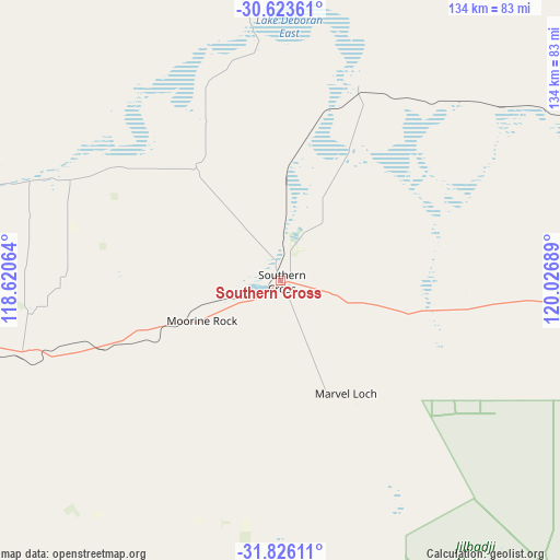
Southern Cross GPS coordinates[2]
31° 13' 36.372" South, 119° 19' 25.536" East
| Map corner | latitude | longitude |
|---|---|---|
| Upper-left | -30.62361°, | 118.62064° |
| Center: | -31.22677°, | 119.32376° |
| Lower-right: | -31.82611°, | 120.02689° |
| Map W x H: | 133.7×133.7 km | = 83.1×83.1mi |
| max Lat: | -10.58257° ⇑29.9% North |
| Southern Cross: | -31.22677° |
| min Lat: | ⇓70.1% South -43.31423° |
| min Long | Southern Cross | max Long |
| 113.53327° | 119.32376° | 153.61246° |
| W 10.5%⇐ | ⇒89.5% E |
Elevation
Elevation of Southern Cross is 362 m = 1188 ft, and this is 240 m = 787 ft above average elevation for this country.
| Max E: |
1715 m = 5627 ft | 10.3% |
| Southern Cross | 362 m 1188 ft | |
| Avg. | 122 m = 400 ft | |
Min E: |
-2 m = -7 ft | 89.7% |
See also: Australia elevation on elevation.city.
Geographical zone
Southern Cross is located in South temperate zone (between Tropic of Capricorn and the Antarctic Circle). Distance of this Southern Tropic circle is 866.2 km =538.2 mi to North.| Distance of | km | miles | from Southern Cross |
|---|---|---|---|
| Equator | 3472.1 | 2157.5 | to North |
| Tropic Capricorn | 866.2 | 538.2 | to North |
| Antarctic Circle | 3929.1 | 2441.4 | to South |
| South Pole | 6535 | 4060.7 | to South |


Nearby cities:
15 places around Southern Cross: (largest is in red/bold)
• Broadwood
208.8 km =129.7 mi,  76°
76°
• Bruce Rock
133.1 km =82.7 mi,  236°
236°
• Coolgardie
177.8 km =110.5 mi, 80°
• Corrigin
184.3 km =114.5 mi,  228°
228°
• Cunderdin
203.9 km =126.7 mi,  256°
256°
• Hannans
210.9 km =131 mi,  74°
74°
• Kellerberrin
158.7 km =98.6 mi,  253°
253°
• Lamington
211 km =131.1 mi, 74°
• Merredin
103.6 km =64.4 mi, 254°
• Piccadilly
211 km =131.1 mi, 75°
• Quairading
202.4 km =125.8 mi, 244°
• Somerville
209.3 km =130.1 mi, 75°
• South Kalgoorlie
211.2 km =131.2 mi, 75°
• Victory Heights
210.8 km =131 mi, 76°
• West Lamington
209.8 km =130.4 mi, 75°
Sources, notices
• [Note1] Compared only with cities in Australia existing in our database
• [Src1] Map data: © OpenStreetMap contributors (CC-BY-SA)
• [Src2] Other city data from geonames.org with taken over terms of usage.
• [Src3] Geographical zone / Annual Mean Temperature by Robert A. Rohde @ Wikipedia
