Merredin geodata
Merredin (Western Australia) is a populated place; located in Australia in Australia/Perth (GMT+8) time zone. With population of 2,851 people, there are 2345 cities with bigger population in this country. Compared to other cities in Australia, 69.7% of cities are located further ↓South; 89.6% of cities are located further →East and 88.2% of cities have lower elevation than Merredin. Note1


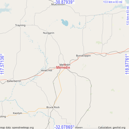
Merredin GPS coordinates[2]
31° 28' 51.384" South, 118° 16' 28.128" East
| Map corner | latitude | longitude |
|---|---|---|
| Upper-left | -30.87939°, | 117.57136° |
| Center: | -31.48094°, | 118.27448° |
| Lower-right: | -32.07865°, | 118.97761° |
| Map W x H: | 133.3×133.3 km | = 82.8×82.8mi |
| max Lat: | -10.58257° ⇑30.3% North |
| Merredin: | -31.48094° |
| min Lat: | ⇓69.7% South -43.31423° |
| min Long | Merredin | max Long |
| 113.53327° | 118.27448° | 153.61246° |
| W 10.4%⇐ | ⇒89.6% E |
Elevation
Elevation of Merredin is 320 m = 1050 ft, and this is 198 m = 650 ft above average elevation for this country.
| Max E: |
1715 m = 5627 ft | 11.8% |
| Merredin | 320 m 1050 ft | |
| Avg. | 122 m = 400 ft | |
Min E: |
-2 m = -7 ft | 88.2% |
See also: Australia elevation on elevation.city.
Geographical zone
Merredin is located in South temperate zone (between Tropic of Capricorn and the Antarctic Circle). Distance of this Southern Tropic circle is 894.4 km =555.8 mi to North.| Distance of | km | miles | from Merredin |
|---|---|---|---|
| Equator | 3500.4 | 2175 | to North |
| Tropic Capricorn | 894.4 | 555.8 | to North |
| Antarctic Circle | 3900.8 | 2423.8 | to South |
| South Pole | 6506.7 | 4043.1 | to South |


Nearby cities:
15 places around Merredin: (largest is in red/bold)
• Bakers Hill
174.5 km =108.4 mi,  260°
260°
• Beverley
145.2 km =90.2 mi,  241°
241°
• Brookton
155.1 km =96.4 mi,  230°
230°
• Bruce Rock
46 km =28.6 mi,  195°
195°
• Corrigin
102.2 km =63.5 mi, 201°
• Cunderdin
100.5 km =62.4 mi, 258°
• Goomalling
139 km =86.4 mi,  278°
278°
• Kellerberrin
55.2 km =34.3 mi,  252°
252°
• Northam
152.8 km =94.9 mi, 262°
• Pingelly
162.2 km =100.8 mi,  223°
223°
• Quairading
101.9 km =63.3 mi, 234°
• Southern Cross
103.6 km =64.4 mi,  74°
74°
• Toodyay
171.5 km =106.6 mi,  267°
267°
• Wongan Hills
161.7 km =100.5 mi,  293°
293°
• York
149.6 km =93 mi, 252°
Sources, notices
• [Note1] Compared only with cities in Australia existing in our database
• [Src1] Map data: © OpenStreetMap contributors (CC-BY-SA)
• [Src2] Other city data from geonames.org with taken over terms of usage.
• [Src3] Geographical zone / Annual Mean Temperature by Robert A. Rohde @ Wikipedia
