Mount Compass geodata
Mount Compass (South Australia) is a populated place; located in Australia in Australia/Adelaide (GMT+10.5) time zone. With population of 1,397 people, there are 3373 cities with bigger population in this country. Compared to other cities in Australia, 76% of cities are located further ↑North; 80.7% of cities are located further →East and 84.3% of cities have lower elevation than Mount Compass. Note1


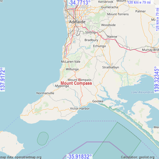
Mount Compass GPS coordinates[2]
35° 20' 48.66" South, 138° 37' 13.152" East
| Map corner | latitude | longitude |
|---|---|---|
| Upper-left | -34.7713°, | 137.9172° |
| Center: | -35.34685°, | 138.62032° |
| Lower-right: | -35.91832°, | 139.32345° |
| Map W x H: | 127.5×127.5 km | = 79.2×79.2mi |
| max Lat: | -10.58257° ⇑76% North |
| Mount Compass: | -35.34685° |
| min Lat: | ⇓24% South -43.31423° |
| min Long | Mount Compass | max Long |
| 113.53327° | 138.62032° | 153.61246° |
| W 19.3%⇐ | ⇒80.7% E |
Elevation
Elevation of Mount Compass is 236 m = 774 ft, and this is 114 m = 374 ft above average elevation for this country.
| Max E: |
1715 m = 5627 ft | 15.7% |
| Mount Compass | 236 m 774 ft | |
| Avg. | 122 m = 400 ft | |
Min E: |
-2 m = -7 ft | 84.3% |
See also: Australia elevation on elevation.city.
Geographical zone
Mount Compass is located in South temperate zone (between Tropic of Capricorn and the Antarctic Circle). Distance of this Southern Tropic circle is 1324.3 km =822.9 mi to North.| Distance of | km | miles | from Mount Compass |
|---|---|---|---|
| Equator | 3930.2 | 2442.1 | to North |
| Tropic Capricorn | 1324.3 | 822.9 | to North |
| Antarctic Circle | 3471 | 2156.8 | to South |
| South Pole | 6076.9 | 3776 | to South |


Nearby cities:
15 places around Mount Compass: (largest is in red/bold)
• Aldinga
14.3 km =8.9 mi,  299°
299°
• Aldinga Beach
16.6 km =10.3 mi, 297°
• Hayborough
20.7 km =12.9 mi,  172°
172°
• Maslin Beach
18.5 km =11.5 mi,  316°
316°
• McCracken
21 km =13 mi,  177°
177°
• McLaren Flat
14.9 km =9.3 mi,  346°
346°
• McLaren Vale
15.8 km =9.8 mi,  333°
333°
• Middleton
19.7 km =12.2 mi,  157°
157°
• Myponga
14.9 km =9.3 mi,  244°
244°
• Old Noarlunga
21.3 km =13.2 mi, 329°
• Port Elliot
21.1 km =13.1 mi, 165°
• Port Willunga
17 km =10.6 mi, 303°
• Seaford Rise
21.2 km =13.2 mi, 323°
• Sellicks Beach
15.7 km =9.8 mi,  273°
273°
• Willunga
10.3 km =6.4 mi, 324°
Sources, notices
• [Note1] Compared only with cities in Australia existing in our database
• [Src1] Map data: © OpenStreetMap contributors (CC-BY-SA)
• [Src2] Other city data from geonames.org with taken over terms of usage.
• [Src3] Geographical zone / Annual Mean Temperature by Robert A. Rohde @ Wikipedia
