Willunga geodata
Willunga (South Australia) is a populated place; located in Australia in Australia/Adelaide (GMT+10.5) time zone. With population of 2,269 people, there are 2717 cities with bigger population in this country. Compared to other cities in Australia, 75.2% of cities are located further ↑North; 82.9% of cities are located further →East and 73.5% of cities have lower elevation than Willunga. Note1


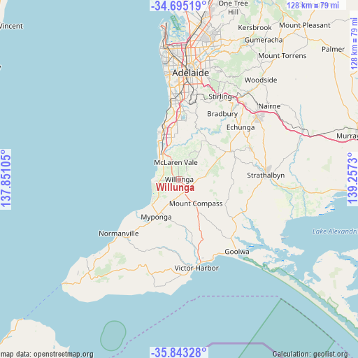
Willunga GPS coordinates[2]
35° 16' 16.572" South, 138° 33' 15.012" East
| Map corner | latitude | longitude |
|---|---|---|
| Upper-left | -34.69519°, | 137.85105° |
| Center: | -35.27127°, | 138.55417° |
| Lower-right: | -35.84328°, | 139.2573° |
| Map W x H: | 127.7×127.7 km | = 79.3×79.3mi |
| max Lat: | -10.58257° ⇑75.2% North |
| Willunga: | -35.27127° |
| min Lat: | ⇓24.8% South -43.31423° |
| min Long | Willunga | max Long |
| 113.53327° | 138.55417° | 153.61246° |
| W 17.1%⇐ | ⇒82.9% E |
Elevation
Elevation of Willunga is 120 m = 394 ft, and this is 2 m = 7 ft below average elevation for this country.
| Max E: |
1715 m = 5627 ft | 26.5% |
| Avg. | 122 m = 400 ft | |
| Willunga | 120 m = 394 ft | |
Min E: |
-2 m = -7 ft | 73.5% |
See also: Australia elevation on elevation.city.
Geographical zone
Willunga is located in South temperate zone (between Tropic of Capricorn and the Antarctic Circle). Distance of this Southern Tropic circle is 1315.9 km =817.7 mi to North.| Distance of | km | miles | from Willunga |
|---|---|---|---|
| Equator | 3921.8 | 2436.9 | to North |
| Tropic Capricorn | 1315.9 | 817.7 | to North |
| Antarctic Circle | 3479.4 | 2162 | to South |
| South Pole | 6085.3 | 3781.2 | to South |


Nearby cities:
15 places around Willunga: (largest is in red/bold)
• Aldinga
6.6 km =4.1 mi,  258°
258°
• Aldinga Beach
8.8 km =5.5 mi, 264°
• Hackham
13.2 km =8.2 mi,  348°
348°
• Maslin Beach
8.4 km =5.2 mi,  306°
306°
• McLaren Flat
6.6 km =4.1 mi,  23°
23°
• McLaren Vale
5.9 km =3.7 mi, 350°
• Moana
11.1 km =6.9 mi,  320°
320°
• Mount Compass
10.3 km =6.4 mi,  144°
144°
• Old Noarlunga
11 km =6.8 mi,  334°
334°
• Port Noarlunga South
13.3 km =8.3 mi, 324°
• Port Willunga
8.2 km =5.1 mi,  277°
277°
• Seaford
11.5 km =7.1 mi, 321°
• Seaford Meadows
12.5 km =7.8 mi, 331°
• Seaford Rise
10.9 km =6.8 mi, 322°
• Sellicks Beach
12.3 km =7.6 mi,  232°
232°
Sources, notices
• [Note1] Compared only with cities in Australia existing in our database
• [Src1] Map data: © OpenStreetMap contributors (CC-BY-SA)
• [Src2] Other city data from geonames.org with taken over terms of usage.
• [Src3] Geographical zone / Annual Mean Temperature by Robert A. Rohde @ Wikipedia
