Modbury geodata
Modbury (South Australia) is a section of populated place; located in Australia in Australia/Adelaide (GMT+10.5) time zone. With population of 5,306 people, there are 1400 cities with bigger population in this country. Compared to other cities in Australia, 66.3% of cities are located further ↑North; 78.5% of cities are located further →East and 71.1% of cities have lower elevation than Modbury. Note1


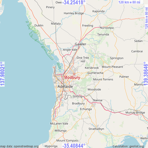
Modbury GPS coordinates[2]
34° 49' 59.988" South, 138° 40' 59.988" East
| Map corner | latitude | longitude |
|---|---|---|
| Upper-left | -34.25418°, | 137.98021° |
| Center: | -34.83333°, | 138.68333° |
| Lower-right: | -35.40844°, | 139.38646° |
| Map W x H: | 128.3×128.3 km | = 79.7×79.7mi |
| max Lat: | -10.58257° ⇑66.3% North |
| Modbury: | -34.83333° |
| min Lat: | ⇓33.7% South -43.31423° |
| min Long | Modbury | max Long |
| 113.53327° | 138.68333° | 153.61246° |
| W 21.5%⇐ | ⇒78.5% E |
Elevation
Elevation of Modbury is 109 m = 358 ft, and this is 13 m = 43 ft below average elevation for this country.
| Max E: |
1715 m = 5627 ft | 28.9% |
| Avg. | 122 m = 400 ft | |
| Modbury | 109 m = 358 ft | |
Min E: |
-2 m = -7 ft | 71.1% |
See also: Australia elevation on elevation.city.
Geographical zone
Modbury is located in South temperate zone (between Tropic of Capricorn and the Antarctic Circle). Distance of this Southern Tropic circle is 1267.2 km =787.4 mi to North.| Distance of | km | miles | from Modbury |
|---|---|---|---|
| Equator | 3873.1 | 2406.6 | to North |
| Tropic Capricorn | 1267.2 | 787.4 | to North |
| Antarctic Circle | 3528.1 | 2192.3 | to South |
| South Pole | 6134 | 3811.5 | to South |


Nearby cities:
15 places around Modbury: (largest is in red/bold)
• Dernancourt
3.2 km =2 mi,  190°
190°
• Gilles Plains
3.6 km =2.2 mi,  238°
238°
• Highbury
2.5 km =1.6 mi,  149°
149°
• Holden Hill
2.3 km =1.4 mi,  206°
206°
• Hope Valley
1.5 km =0.9 mi,  90°
90°
• Modbury Heights
2.6 km =1.6 mi,  4°
4°
• Modbury North
1 km =0.6 mi,  302°
302°
• Para Hills
3.3 km =2.1 mi,  315°
315°
• Para Vista
2.5 km =1.6 mi, 304°
• Redwood Park
3.2 km =2 mi,  41°
41°
• Ridgehaven
2.4 km =1.5 mi,  55°
55°
• St Agnes
2.5 km =1.6 mi,  83°
83°
• Valley View
2.2 km =1.4 mi,  250°
250°
• Vista
3.6 km =2.2 mi, 93°
• Walkley Heights
3.6 km =2.2 mi,  264°
264°
Sources, notices
• [Note1] Compared only with cities in Australia existing in our database
• [Src1] Map data: © OpenStreetMap contributors (CC-BY-SA)
• [Src2] Other city data from geonames.org with taken over terms of usage.
• [Src3] Geographical zone / Annual Mean Temperature by Robert A. Rohde @ Wikipedia
