Ridgehaven geodata
Ridgehaven (South Australia) is a section of populated place; located in Australia in Australia/Adelaide (GMT+10.5) time zone. With population of 3,926 people, there are 1817 cities with bigger population in this country. Compared to other cities in Australia, 66.1% of cities are located further ↑North; 78.1% of cities are located further →East and 78% of cities have lower elevation than Ridgehaven. Note1


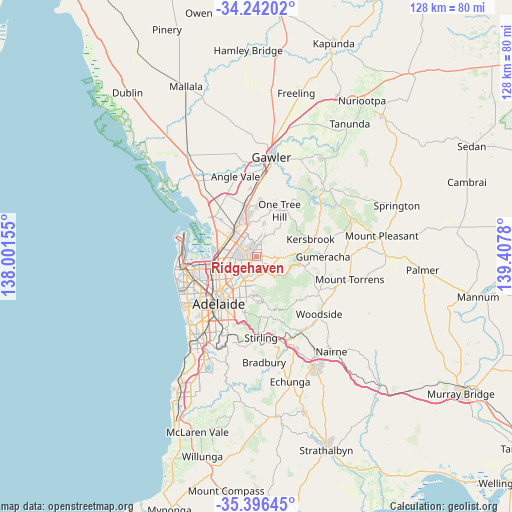
Ridgehaven GPS coordinates[2]
34° 49' 16.536" South, 138° 42' 16.812" East
| Map corner | latitude | longitude |
|---|---|---|
| Upper-left | -34.24202°, | 138.00155° |
| Center: | -34.82126°, | 138.70467° |
| Lower-right: | -35.39645°, | 139.4078° |
| Map W x H: | 128.4×128.4 km | = 79.8×79.8mi |
| max Lat: | -10.58257° ⇑66.1% North |
| Ridgehaven: | -34.82126° |
| min Lat: | ⇓33.9% South -43.31423° |
| min Long | Ridgehaven | max Long |
| 113.53327° | 138.70467° | 153.61246° |
| W 21.9%⇐ | ⇒78.1% E |
Elevation
Elevation of Ridgehaven is 156 m = 512 ft, and this is 34 m = 112 ft above average elevation for this country.
| Max E: |
1715 m = 5627 ft | 22% |
| Ridgehaven | 156 m 512 ft | |
| Avg. | 122 m = 400 ft | |
Min E: |
-2 m = -7 ft | 78% |
See also: Australia elevation on elevation.city.
Geographical zone
Ridgehaven is located in South temperate zone (between Tropic of Capricorn and the Antarctic Circle). Distance of this Southern Tropic circle is 1265.8 km =786.5 mi to North.| Distance of | km | miles | from Ridgehaven |
|---|---|---|---|
| Equator | 3871.8 | 2405.8 | to North |
| Tropic Capricorn | 1265.8 | 786.5 | to North |
| Antarctic Circle | 3529.4 | 2193.1 | to South |
| South Pole | 6135.3 | 3812.3 | to South |


Nearby cities:
15 places around Ridgehaven: (largest is in red/bold)
• Banksia Park
3.1 km =1.9 mi,  66°
66°
• Fairview Park
3.2 km =2 mi,  42°
42°
• Gulfview Heights
4.3 km =2.7 mi,  311°
311°
• Highbury
3.6 km =2.2 mi,  190°
190°
• Hope Valley
1.4 km =0.9 mi,  197°
197°
• Modbury
2.4 km =1.5 mi,  235°
235°
• Modbury Heights
2.2 km =1.4 mi, 306°
• Modbury North
2.9 km =1.8 mi,  254°
254°
• Para Vista
4 km =2.5 mi,  270°
270°
• Redwood Park
1.1 km =0.7 mi,  10°
10°
• St Agnes
1.2 km =0.7 mi,  152°
152°
• Surrey Downs
2.5 km =1.6 mi, 14°
• Tea Tree Gully
2.7 km =1.7 mi,  78°
78°
• Vista
2.3 km =1.4 mi,  133°
133°
• Wynn Vale
2.9 km =1.8 mi,  326°
326°
Sources, notices
• [Note1] Compared only with cities in Australia existing in our database
• [Src1] Map data: © OpenStreetMap contributors (CC-BY-SA)
• [Src2] Other city data from geonames.org with taken over terms of usage.
• [Src3] Geographical zone / Annual Mean Temperature by Robert A. Rohde @ Wikipedia
