Vista geodata
Vista (South Australia) is a section of populated place; located in Australia in Australia/Adelaide (GMT+10.5) time zone. With population of 930 people, there are 3931 cities with bigger population in this country. Compared to other cities in Australia, 66.3% of cities are located further ↑North; 77.9% of cities are located further →East and 82.5% of cities have lower elevation than Vista. Note1


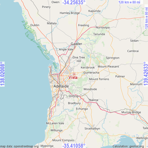
Vista GPS coordinates[2]
34° 50' 7.764" South, 138° 43' 23.52" East
| Map corner | latitude | longitude |
|---|---|---|
| Upper-left | -34.25635°, | 138.02008° |
| Center: | -34.83549°, | 138.7232° |
| Lower-right: | -35.41058°, | 139.42633° |
| Map W x H: | 128.3×128.3 km | = 79.7×79.7mi |
| max Lat: | -10.58257° ⇑66.3% North |
| Vista: | -34.83549° |
| min Lat: | ⇓33.7% South -43.31423° |
| min Long | Vista | max Long |
| 113.53327° | 138.7232° | 153.61246° |
| W 22.1%⇐ | ⇒77.9% E |
Elevation
Elevation of Vista is 211 m = 692 ft, and this is 89 m = 292 ft above average elevation for this country.
| Max E: |
1715 m = 5627 ft | 17.5% |
| Vista | 211 m 692 ft | |
| Avg. | 122 m = 400 ft | |
Min E: |
-2 m = -7 ft | 82.5% |
See also: Australia elevation on elevation.city.
Geographical zone
Vista is located in South temperate zone (between Tropic of Capricorn and the Antarctic Circle). Distance of this Southern Tropic circle is 1267.4 km =787.5 mi to North.| Distance of | km | miles | from Vista |
|---|---|---|---|
| Equator | 3873.3 | 2406.8 | to North |
| Tropic Capricorn | 1267.4 | 787.5 | to North |
| Antarctic Circle | 3527.8 | 2192.1 | to South |
| South Pole | 6133.7 | 3811.3 | to South |


Nearby cities:
15 places around Vista: (largest is in red/bold)
• Athelstone
4.4 km =2.7 mi,  208°
208°
• Banksia Park
3 km =1.9 mi,  22°
22°
• Dernancourt
5.2 km =3.2 mi,  235°
235°
• Fairview Park
4 km =2.5 mi,  7°
7°
• Highbury
3 km =1.9 mi,  230°
230°
• Holden Hill
5 km =3.1 mi,  248°
248°
• Hope Valley
2.1 km =1.3 mi,  276°
276°
• Modbury
3.6 km =2.2 mi,  273°
273°
• Modbury Heights
4.5 km =2.8 mi,  309°
309°
• Modbury North
4.6 km =2.9 mi, 279°
• Redwood Park
3 km =1.9 mi,  330°
330°
• Ridgehaven
2.3 km =1.4 mi, 313°
• St Agnes
1.3 km =0.8 mi,  294°
294°
• Surrey Downs
4.1 km =2.5 mi,  345°
345°
• Tea Tree Gully
2.3 km =1.4 mi, 23°
Sources, notices
• [Note1] Compared only with cities in Australia existing in our database
• [Src1] Map data: © OpenStreetMap contributors (CC-BY-SA)
• [Src2] Other city data from geonames.org with taken over terms of usage.
• [Src3] Geographical zone / Annual Mean Temperature by Robert A. Rohde @ Wikipedia
