Laverton geodata
Laverton (Western Australia) is a populated place; located in Australia in Australia/Perth (GMT+8) time zone. With population of 2,121 people, there are 2809 cities with bigger population in this country. Compared to other cities in Australia, 74.3% of cities are located further ↓South; 88.8% of cities are located further →East and 92.8% of cities have lower elevation than Laverton. Note1


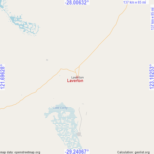
Laverton GPS coordinates[2]
28° 37' 31.116" South, 122° 23' 57.84" East
| Map corner | latitude | longitude |
|---|---|---|
| Upper-left | -28.00632°, | 121.69628° |
| Center: | -28.62531°, | 122.3994° |
| Lower-right: | -29.24067°, | 123.10253° |
| Map W x H: | 137.2×137.2 km | = 85.3×85.3mi |
| max Lat: | -10.58257° ⇑25.7% North |
| Laverton: | -28.62531° |
| min Lat: | ⇓74.3% South -43.31423° |
| min Long | Laverton | max Long |
| 113.53327° | 122.3994° | 153.61246° |
| W 11.2%⇐ | ⇒88.8% E |
Elevation
Elevation of Laverton is 464 m = 1522 ft, and this is 342 m = 1122 ft above average elevation for this country.
| Max E: |
1715 m = 5627 ft | 7.2% |
| Laverton | 464 m 1522 ft | |
| Avg. | 122 m = 400 ft | |
Min E: |
-2 m = -7 ft | 92.8% |
See also: Australia elevation on elevation.city.
Geographical zone
Laverton is located in South temperate zone (between Tropic of Capricorn and the Antarctic Circle). Distance of this Southern Tropic circle is 576.9 km =358.5 mi to North.| Distance of | km | miles | from Laverton |
|---|---|---|---|
| Equator | 3182.8 | 1977.7 | to North |
| Tropic Capricorn | 576.9 | 358.5 | to North |
| Antarctic Circle | 4218.3 | 2621.1 | to South |
| South Pole | 6824.2 | 4240.4 | to South |


Nearby cities:
15 places around Laverton: (largest is in red/bold)
• Boulder
255.3 km =158.6 mi,  200°
200°
• Broadwood
257.4 km =159.9 mi, 200°
• Coolgardie
284.9 km =177 mi, 204°
• Hannans
250 km =155.3 mi, 201°
• Kalgoorlie
252.2 km =156.7 mi, 200°
• Kambalda East
295.4 km =183.6 mi,  193°
193°
• Lamington
251.4 km =156.2 mi, 201°
• Leinster
184.2 km =114.5 mi,  295°
295°
• Leonora
108.1 km =67.2 mi,  254°
254°
• Piccadilly
252.2 km =156.7 mi, 200°
• Somerville
255.3 km =158.6 mi, 200°
• South Kalgoorlie
254.2 km =158 mi, 200°
• Stoneville
256.6 km =159.4 mi, 193°
• Victory Heights
255.6 km =158.8 mi, 200°
• West Lamington
253 km =157.2 mi, 201°
Sources, notices
• [Note1] Compared only with cities in Australia existing in our database
• [Src1] Map data: © OpenStreetMap contributors (CC-BY-SA)
• [Src2] Other city data from geonames.org with taken over terms of usage.
• [Src3] Geographical zone / Annual Mean Temperature by Robert A. Rohde @ Wikipedia
