Karnup geodata
Karnup (Western Australia) is a section of populated place; located in Australia in Australia/Perth (GMT+8) time zone. With population of 1,351 people, there are 3414 cities with bigger population in this country. Compared to other cities in Australia, 61.8% of cities are located further ↓South; 96.4% of cities are located further →East and 72.3% of cities have higher elevation than Karnup. Note1


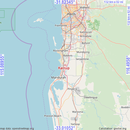
Karnup GPS coordinates[2]
32° 25' 8.184" South, 115° 47' 33.612" East
| Map corner | latitude | longitude |
|---|---|---|
| Upper-left | -31.82345°, | 115.08955° |
| Center: | -32.41894°, | 115.79267° |
| Lower-right: | -33.01052°, | 116.4958° |
| Map W x H: | 132×132 km | = 82×82mi |
| max Lat: | -10.58257° ⇑38.2% North |
| Karnup: | -32.41894° |
| min Lat: | ⇓61.8% South -43.31423° |
| min Long | Karnup | max Long |
| 113.53327° | 115.79267° | 153.61246° |
| W 3.6%⇐ | ⇒96.4% E |
Elevation
Elevation of Karnup is 21 m = 69 ft, and this is 101 m = 331 ft below average elevation for this country.
| Max E: |
1715 m = 5627 ft | 72.3% |
| Avg. | 122 m = 400 ft | |
| Karnup | 21 m = 69 ft | |
Min E: |
-2 m = -7 ft | 27.7% |
See also: Australia elevation on elevation.city.
Geographical zone
Karnup is located in South temperate zone (between Tropic of Capricorn and the Antarctic Circle). Distance of this Southern Tropic circle is 998.7 km =620.6 mi to North.| Distance of | km | miles | from Karnup |
|---|---|---|---|
| Equator | 3604.6 | 2239.8 | to North |
| Tropic Capricorn | 998.7 | 620.6 | to North |
| Antarctic Circle | 3796.5 | 2359 | to South |
| South Pole | 6402.4 | 3978.3 | to South |


Nearby cities:
15 places around Karnup: (largest is in red/bold)
• Baldivis
10.6 km =6.6 mi,  19°
19°
• Cooloongup
11.6 km =7.2 mi,  353°
353°
• Golden Bay
3.1 km =1.9 mi,  257°
257°
• Greenfields
12 km =7.5 mi,  193°
193°
• Lakelands
6.1 km =3.8 mi,  197°
197°
• Madora Bay
6.8 km =4.2 mi,  213°
213°
• Meadow Springs
9.4 km =5.8 mi, 202°
• Parklands
8.7 km =5.4 mi, 192°
• Port Kennedy
6.4 km =4 mi,  322°
322°
• San Remo
9.1 km =5.7 mi, 209°
• Secret Harbour
3.5 km =2.2 mi,  294°
294°
• Silver Sands
11.3 km =7 mi, 208°
• Singleton
4.3 km =2.7 mi,  229°
229°
• Waikiki
12 km =7.5 mi,  342°
342°
• Warnbro
9.7 km =6 mi,  334°
334°
Sources, notices
• [Note1] Compared only with cities in Australia existing in our database
• [Src1] Map data: © OpenStreetMap contributors (CC-BY-SA)
• [Src2] Other city data from geonames.org with taken over terms of usage.
• [Src3] Geographical zone / Annual Mean Temperature by Robert A. Rohde @ Wikipedia
