Baldivis geodata
Baldivis (Western Australia) is a section of populated place; located in Australia in Australia/Perth (GMT+8) time zone. With population of 30,472 people, there are 66 cities with bigger population in this country. Compared to other cities in Australia, 62.2% of cities are located further ↓South; 95.3% of cities are located further →East and 98.1% of cities have higher elevation than Baldivis. Note1


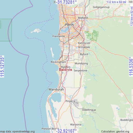
Baldivis GPS coordinates[2]
32° 19' 44.004" South, 115° 49' 49.692" East
| Map corner | latitude | longitude |
|---|---|---|
| Upper-left | -31.73281°, | 115.12735° |
| Center: | -32.32889°, | 115.83047° |
| Lower-right: | -32.92107°, | 116.5336° |
| Map W x H: | 132.1×132.1 km | = 82.1×82.1mi |
| max Lat: | -10.58257° ⇑37.8% North |
| Baldivis: | -32.32889° |
| min Lat: | ⇓62.2% South -43.31423° |
| min Long | Baldivis | max Long |
| 113.53327° | 115.83047° | 153.61246° |
| W 4.7%⇐ | ⇒95.3% E |
Elevation
Elevation of Baldivis is 4 m = 13 ft, and this is 118 m = 387 ft below average elevation for this country.
| Max E: |
1715 m = 5627 ft | 98.1% |
| Avg. | 122 m = 400 ft | |
| Baldivis | 4 m = 13 ft | |
Min E: |
-2 m = -7 ft | 1.9% |
See also: Australia elevation on elevation.city.
Geographical zone
Baldivis is located in South temperate zone (between Tropic of Capricorn and the Antarctic Circle). Distance of this Southern Tropic circle is 988.7 km =614.3 mi to North.| Distance of | km | miles | from Baldivis |
|---|---|---|---|
| Equator | 3594.6 | 2233.6 | to North |
| Tropic Capricorn | 988.7 | 614.3 | to North |
| Antarctic Circle | 3806.5 | 2365.2 | to South |
| South Pole | 6412.4 | 3984.5 | to South |


Nearby cities:
15 places around Baldivis: (largest is in red/bold)
• Bertram
9.6 km =6 mi,  8°
8°
• Calista
10.2 km =6.3 mi,  342°
342°
• Casuarina
10.4 km =6.5 mi,  20°
20°
• Cooloongup
5.2 km =3.2 mi,  287°
287°
• Hillman
8.1 km =5 mi,  308°
308°
• Karnup
10.6 km =6.6 mi,  199°
199°
• Leda
7.4 km =4.6 mi, 336°
• Orelia
10.7 km =6.6 mi,  355°
355°
• Parmelia
7.9 km =4.9 mi,  354°
354°
• Port Kennedy
8.9 km =5.5 mi,  236°
236°
• Rockingham city centre
10.2 km =6.3 mi,  299°
299°
• Safety Bay
8.7 km =5.4 mi, 288°
• Waikiki
7.3 km =4.5 mi,  281°
281°
• Warnbro
7.9 km =4.9 mi,  260°
260°
• Wellard
6.9 km =4.3 mi,  2°
2°
Sources, notices
• [Note1] Compared only with cities in Australia existing in our database
• [Src1] Map data: © OpenStreetMap contributors (CC-BY-SA)
• [Src2] Other city data from geonames.org with taken over terms of usage.
• [Src3] Geographical zone / Annual Mean Temperature by Robert A. Rohde @ Wikipedia
