Kalgan geodata
Kalgan (Western Australia) is a section of populated place; located in Australia in Australia/Perth (GMT+8) time zone. With population of 805 people, there are 4135 cities with bigger population in this country. Compared to other cities in Australia, 67.7% of cities are located further ↑North; 89.7% of cities are located further →East and 54.5% of cities have lower elevation than Kalgan. Note1


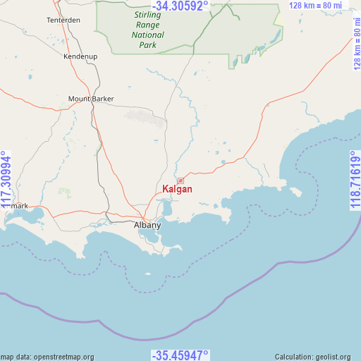
Kalgan GPS coordinates[2]
34° 53' 4.992" South, 118° 0' 47.016" East
| Map corner | latitude | longitude |
|---|---|---|
| Upper-left | -34.30592°, | 117.30994° |
| Center: | -34.88472°, | 118.01306° |
| Lower-right: | -35.45947°, | 118.71619° |
| Map W x H: | 128.3×128.3 km | = 79.7×79.7mi |
| max Lat: | -10.58257° ⇑67.7% North |
| Kalgan: | -34.88472° |
| min Lat: | ⇓32.3% South -43.31423° |
| min Long | Kalgan | max Long |
| 113.53327° | 118.01306° | 153.61246° |
| W 10.3%⇐ | ⇒89.7% E |
Elevation
Elevation of Kalgan is 52 m = 171 ft, and this is 70 m = 230 ft below average elevation for this country.
| Max E: |
1715 m = 5627 ft | 45.5% |
| Avg. | 122 m = 400 ft | |
| Kalgan | 52 m = 171 ft | |
Min E: |
-2 m = -7 ft | 54.5% |
See also: Australia elevation on elevation.city.
Geographical zone
Kalgan is located in South temperate zone (between Tropic of Capricorn and the Antarctic Circle). Distance of this Southern Tropic circle is 1272.9 km =790.9 mi to North.| Distance of | km | miles | from Kalgan |
|---|---|---|---|
| Equator | 3878.8 | 2410.2 | to North |
| Tropic Capricorn | 1272.9 | 790.9 | to North |
| Antarctic Circle | 3522.4 | 2188.7 | to South |
| South Pole | 6128.2 | 3807.9 | to South |


Nearby cities:
15 places around Kalgan: (largest is in red/bold)
• Albany city centre
19.5 km =12.1 mi,  216°
216°
• Bayonet Head
12.2 km =7.6 mi, 216°
• Centennial Park
18.9 km =11.7 mi, 219°
• Collingwood Heights
14.7 km =9.1 mi, 215°
• Lockyer
19.5 km =12.1 mi,  226°
226°
• Lower King
10.6 km =6.6 mi, 219°
• Middleton Beach
18 km =11.2 mi,  211°
211°
• Milpara
17.6 km =10.9 mi, 229°
• Mira Mar
17.7 km =11 mi, 215°
• Mount Clarence
19 km =11.8 mi, 215°
• Orana
18.7 km =11.6 mi, 228°
• Spencer Park
16.9 km =10.5 mi, 217°
• Warrenup
18.2 km =11.3 mi,  236°
236°
• Willyung
13.8 km =8.6 mi, 241°
• Yakamia
18.1 km =11.2 mi, 222°
Sources, notices
• [Note1] Compared only with cities in Australia existing in our database
• [Src1] Map data: © OpenStreetMap contributors (CC-BY-SA)
• [Src2] Other city data from geonames.org with taken over terms of usage.
• [Src3] Geographical zone / Annual Mean Temperature by Robert A. Rohde @ Wikipedia
