Cheltenham geodata
Cheltenham (South Australia) is a populated place; located in Australia in Australia/Adelaide (GMT+10.5) time zone. With population of 2,176 people, there are 2773 cities with bigger population in this country. Compared to other cities in Australia, 67.1% of cities are located further ↑North; 83.8% of cities are located further →East and 90.1% of cities have higher elevation than Cheltenham. Note1


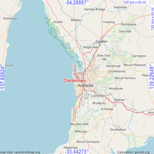
Cheltenham GPS coordinates[2]
34° 52' 4.368" South, 138° 31' 24.096" East
| Map corner | latitude | longitude |
|---|---|---|
| Upper-left | -34.28897°, | 137.82024° |
| Center: | -34.86788°, | 138.52336° |
| Lower-right: | -35.44275°, | 139.22649° |
| Map W x H: | 128.3×128.3 km | = 79.7×79.7mi |
| max Lat: | -10.58257° ⇑67.1% North |
| Cheltenham: | -34.86788° |
| min Lat: | ⇓32.9% South -43.31423° |
| min Long | Cheltenham | max Long |
| 113.53327° | 138.52336° | 153.61246° |
| W 16.2%⇐ | ⇒83.8% E |
Elevation
Elevation of Cheltenham is 9 m = 30 ft, and this is 113 m = 371 ft below average elevation for this country.
| Max E: |
1715 m = 5627 ft | 90.1% |
| Avg. | 122 m = 400 ft | |
| Cheltenham | 9 m = 30 ft | |
Min E: |
-2 m = -7 ft | 9.9% |
See also: Australia elevation on elevation.city.
Geographical zone
Cheltenham is located in South temperate zone (between Tropic of Capricorn and the Antarctic Circle). Distance of this Southern Tropic circle is 1271 km =789.8 mi to North.| Distance of | km | miles | from Cheltenham |
|---|---|---|---|
| Equator | 3876.9 | 2409 | to North |
| Tropic Capricorn | 1271 | 789.8 | to North |
| Antarctic Circle | 3524.2 | 2189.8 | to South |
| South Pole | 6130.1 | 3809.1 | to South |


Nearby cities:
15 places around Cheltenham: (largest is in red/bold)
• Albert Park
0.6 km =0.4 mi,  216°
216°
• Alberton
1 km =0.6 mi,  349°
349°
• Athol Park
2.2 km =1.4 mi,  53°
53°
• Mansfield Park
2.9 km =1.8 mi,  64°
64°
• Ottoway
2.5 km =1.6 mi,  26°
26°
• Pennington
1.4 km =0.9 mi, 33°
• Queenstown
1.4 km =0.9 mi,  303°
303°
• Rosewater
1.8 km =1.1 mi, 354°
• Royal Park
1.3 km =0.8 mi,  236°
236°
• West Lakes
2.7 km =1.7 mi,  257°
257°
• Woodville
2.1 km =1.3 mi,  119°
119°
• Woodville Gardens
2.2 km =1.4 mi,  90°
90°
• Woodville North
1.9 km =1.2 mi,  104°
104°
• Woodville South
1.9 km =1.2 mi,  146°
146°
• Woodville West
2.2 km =1.4 mi,  161°
161°
Sources, notices
• [Note1] Compared only with cities in Australia existing in our database
• [Src1] Map data: © OpenStreetMap contributors (CC-BY-SA)
• [Src2] Other city data from geonames.org with taken over terms of usage.
• [Src3] Geographical zone / Annual Mean Temperature by Robert A. Rohde @ Wikipedia
