Alberton geodata
Alberton (South Australia) is a section of populated place; located in Australia in Australia/Adelaide (GMT+10.5) time zone. With population of 1,792 people, there are 3055 cities with bigger population in this country. Compared to other cities in Australia, 66.9% of cities are located further ↑North; 83.9% of cities are located further →East and 90.1% of cities have higher elevation than Alberton. Note1


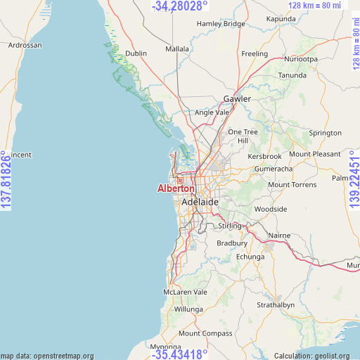
Alberton GPS coordinates[2]
34° 51' 33.3" South, 138° 31' 16.968" East
| Map corner | latitude | longitude |
|---|---|---|
| Upper-left | -34.28028°, | 137.81826° |
| Center: | -34.85925°, | 138.52138° |
| Lower-right: | -35.43418°, | 139.22451° |
| Map W x H: | 128.3×128.3 km | = 79.7×79.7mi |
| max Lat: | -10.58257° ⇑66.9% North |
| Alberton: | -34.85925° |
| min Lat: | ⇓33.1% South -43.31423° |
| min Long | Alberton | max Long |
| 113.53327° | 138.52138° | 153.61246° |
| W 16.1%⇐ | ⇒83.9% E |
Elevation
Elevation of Alberton is 9 m = 30 ft, and this is 113 m = 371 ft below average elevation for this country.
| Max E: |
1715 m = 5627 ft | 90.1% |
| Avg. | 122 m = 400 ft | |
| Alberton | 9 m = 30 ft | |
Min E: |
-2 m = -7 ft | 9.9% |
See also: Australia elevation on elevation.city.
Geographical zone
Alberton is located in South temperate zone (between Tropic of Capricorn and the Antarctic Circle). Distance of this Southern Tropic circle is 1270.1 km =789.2 mi to North.| Distance of | km | miles | from Alberton |
|---|---|---|---|
| Equator | 3876 | 2408.4 | to North |
| Tropic Capricorn | 1270.1 | 789.2 | to North |
| Antarctic Circle | 3525.2 | 2190.5 | to South |
| South Pole | 6131.1 | 3809.7 | to South |


Nearby cities:
15 places around Alberton: (largest is in red/bold)
• Albert Park
1.4 km =0.9 mi,  186°
186°
• Athol Park
2 km =1.2 mi,  79°
79°
• Cheltenham
1 km =0.6 mi,  169°
169°
• Mansfield Park
2.8 km =1.7 mi, 83°
• Ottoway
1.8 km =1.1 mi,  45°
45°
• Pennington
1 km =0.6 mi, 78°
• Port Adelaide
2.2 km =1.4 mi,  310°
310°
• Queenstown
1 km =0.6 mi,  259°
259°
• Rosewater
0.8 km =0.5 mi,  1°
1°
• Royal Park
1.9 km =1.2 mi,  207°
207°
• West Lakes
2.9 km =1.8 mi,  238°
238°
• Woodville
2.8 km =1.7 mi,  135°
135°
• Woodville Gardens
2.6 km =1.6 mi,  111°
111°
• Woodville North
2.4 km =1.5 mi,  125°
125°
• Woodville South
2.8 km =1.7 mi,  154°
154°
Sources, notices
• [Note1] Compared only with cities in Australia existing in our database
• [Src1] Map data: © OpenStreetMap contributors (CC-BY-SA)
• [Src2] Other city data from geonames.org with taken over terms of usage.
• [Src3] Geographical zone / Annual Mean Temperature by Robert A. Rohde @ Wikipedia
