Busselton geodata
Busselton (Western Australia) is a seat of a second-order administrative division; located in Australia in Australia/Perth (GMT+8) time zone. With population of 21,898 people, there are 139 cities with bigger population in this country. Compared to other cities in Australia, 52% of cities are located further ↓South; 98.9% of cities are located further →East and 99.9% of cities have higher elevation than Busselton. Note1


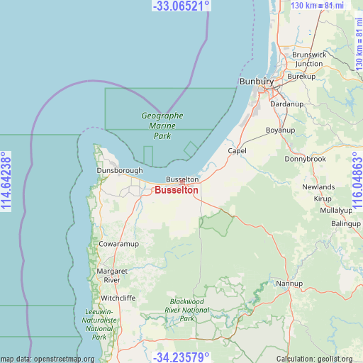
Busselton GPS coordinates[2]
33° 39' 8.964" South, 115° 20' 43.8" East
| Map corner | latitude | longitude |
|---|---|---|
| Upper-left | -33.06521°, | 114.64238° |
| Center: | -33.65249°, | 115.3455° |
| Lower-right: | -34.23579°, | 116.04863° |
| Map W x H: | 130.2×130.2 km | = 80.9×80.9mi |
| max Lat: | -10.58257° ⇑48% North |
| Busselton: | -33.65249° |
| min Lat: | ⇓52% South -43.31423° |
| min Long | Busselton | max Long |
| 113.53327° | 115.3455° | 153.61246° |
| W 1.1%⇐ | ⇒98.9% E |
Elevation
Elevation of Busselton is 1 m = 3 ft, and this is 121 m = 397 ft below average elevation for this country.
| Max E: |
1715 m = 5627 ft | 99.9% |
| Avg. | 122 m = 400 ft | |
| Busselton | 1 m = 3 ft | |
Min E: |
-2 m = -7 ft | 0.1% |
See also: Australia elevation on elevation.city.
Geographical zone
Busselton is located in South temperate zone (between Tropic of Capricorn and the Antarctic Circle). Distance of this Southern Tropic circle is 1135.9 km =705.8 mi to North.| Distance of | km | miles | from Busselton |
|---|---|---|---|
| Equator | 3741.8 | 2325 | to North |
| Tropic Capricorn | 1135.9 | 705.8 | to North |
| Antarctic Circle | 3659.4 | 2273.8 | to South |
| South Pole | 6265.3 | 3893.1 | to South |


Nearby cities:
15 places around Busselton: (largest is in red/bold)
• Abbey
8.3 km =5.2 mi,  261°
261°
• Broadwater
5.8 km =3.6 mi, 258°
• Busselton city cenre
0.4 km =0.2 mi,  61°
61°
• Capel
22.7 km =14.1 mi, 62°
• Cowaramup
31.4 km =19.5 mi,  225°
225°
• Dalyellup
36.9 km =22.9 mi,  42°
42°
• Dunsborough
22.7 km =14.1 mi,  280°
280°
• Geographe
3.8 km =2.4 mi,  68°
68°
• Marybrook
13.1 km =8.1 mi,  269°
269°
• Quindalup
18.3 km =11.4 mi, 275°
• Stratham
30.7 km =19.1 mi,  46°
46°
• Vasse
8.5 km =5.3 mi,  237°
237°
• West Busselton
2.2 km =1.4 mi,  253°
253°
• Yallingup
28.7 km =17.8 mi, 271°
• Yalyalup
6.9 km =4.3 mi,  111°
111°
Sources, notices
• [Note1] Compared only with cities in Australia existing in our database
• [Src1] Map data: © OpenStreetMap contributors (CC-BY-SA)
• [Src2] Other city data from geonames.org with taken over terms of usage.
• [Src3] Geographical zone / Annual Mean Temperature by Robert A. Rohde @ Wikipedia
