Busselton city cenre geodata
Busselton city cenre (Western Australia) is a section of populated place; located in Australia in Australia/Perth (GMT+8) time zone. With population of 1,848 people, there are 3003 cities with bigger population in this country. Compared to other cities in Australia, 52% of cities are located further ↓South; 98.9% of cities are located further →East and 99.9% of cities have higher elevation than Busselton city cenre. Note1


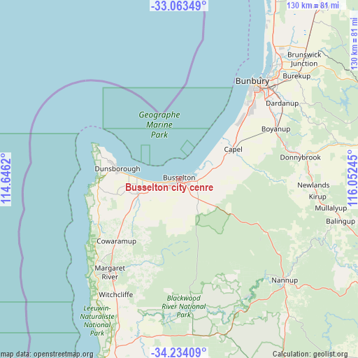
Busselton city cenre GPS coordinates[2]
33° 39' 2.808" South, 115° 20' 57.552" East
| Map corner | latitude | longitude |
|---|---|---|
| Upper-left | -33.06349°, | 114.6462° |
| Center: | -33.65078°, | 115.34932° |
| Lower-right: | -34.23409°, | 116.05245° |
| Map W x H: | 130.2×130.2 km | = 80.9×80.9mi |
| max Lat: | -10.58257° ⇑48% North |
| Busselton city cenre: | -33.65078° |
| min Lat: | ⇓52% South -43.31423° |
| min Long | Busselton city | max Long |
| 113.53327° | 115.34932° | 153.61246° |
| W 1.1%⇐ | ⇒98.9% E |
Elevation
Elevation of Busselton city cenre is 1 m = 3 ft, and this is 121 m = 397 ft below average elevation for this country.
| Max E: |
1715 m = 5627 ft | 99.9% |
| Avg. | 122 m = 400 ft | |
| Busselton city cenre | 1 m = 3 ft | |
Min E: |
-2 m = -7 ft | 0.1% |
See also: Australia elevation on elevation.city.
Geographical zone
Busselton city cenre is located in South temperate zone (between Tropic of Capricorn and the Antarctic Circle). Distance of this Southern Tropic circle is 1135.7 km =705.7 mi to North.| Distance of | km | miles | from Busselton city cenre |
|---|---|---|---|
| Equator | 3741.6 | 2324.9 | to North |
| Tropic Capricorn | 1135.7 | 705.7 | to North |
| Antarctic Circle | 3659.6 | 2274 | to South |
| South Pole | 6265.4 | 3893.1 | to South |


Nearby cities:
15 places around Busselton city cenre: (largest is in red/bold)
• Abbey
8.7 km =5.4 mi,  260°
260°
• Broadwater
6.2 km =3.9 mi, 257°
• Busselton
0.4 km =0.2 mi,  241°
241°
• Capel
22.3 km =13.9 mi,  62°
62°
• Cowaramup
31.7 km =19.7 mi,  225°
225°
• Dalyellup
36.5 km =22.7 mi,  42°
42°
• Dunsborough
23 km =14.3 mi,  280°
280°
• Geographe
3.4 km =2.1 mi,  68°
68°
• Marybrook
13.5 km =8.4 mi,  269°
269°
• Quindalup
18.6 km =11.6 mi, 275°
• Stratham
30.3 km =18.8 mi,  46°
46°
• Vasse
8.9 km =5.5 mi, 237°
• West Busselton
2.6 km =1.6 mi,  251°
251°
• Yallingup
29.1 km =18.1 mi, 271°
• Yalyalup
6.6 km =4.1 mi,  114°
114°
Sources, notices
• [Note1] Compared only with cities in Australia existing in our database
• [Src1] Map data: © OpenStreetMap contributors (CC-BY-SA)
• [Src2] Other city data from geonames.org with taken over terms of usage.
• [Src3] Geographical zone / Annual Mean Temperature by Robert A. Rohde @ Wikipedia
