Capel geodata
Capel (Western Australia) is a populated place; located in Australia in Australia/Perth (GMT+8) time zone. With population of 2,391 people, there are 2634 cities with bigger population in this country. Compared to other cities in Australia, 52.9% of cities are located further ↓South; 98.8% of cities are located further →East and 76.1% of cities have higher elevation than Capel. Note1


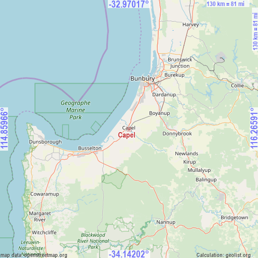
Capel GPS coordinates[2]
33° 33' 29.088" South, 115° 33' 46.008" East
| Map corner | latitude | longitude |
|---|---|---|
| Upper-left | -32.97017°, | 114.85966° |
| Center: | -33.55808°, | 115.56278° |
| Lower-right: | -34.14202°, | 116.26591° |
| Map W x H: | 130.3×130.3 km | = 81×81mi |
| max Lat: | -10.58257° ⇑47.1% North |
| Capel: | -33.55808° |
| min Lat: | ⇓52.9% South -43.31423° |
| min Long | Capel | max Long |
| 113.53327° | 115.56278° | 153.61246° |
| W 1.2%⇐ | ⇒98.8% E |
Elevation
Elevation of Capel is 18 m = 59 ft, and this is 104 m = 341 ft below average elevation for this country.
| Max E: |
1715 m = 5627 ft | 76.1% |
| Avg. | 122 m = 400 ft | |
| Capel | 18 m = 59 ft | |
Min E: |
-2 m = -7 ft | 23.9% |
See also: Australia elevation on elevation.city.
Geographical zone
Capel is located in South temperate zone (between Tropic of Capricorn and the Antarctic Circle). Distance of this Southern Tropic circle is 1125.4 km =699.3 mi to North.| Distance of | km | miles | from Capel |
|---|---|---|---|
| Equator | 3731.3 | 2318.5 | to North |
| Tropic Capricorn | 1125.4 | 699.3 | to North |
| Antarctic Circle | 3669.9 | 2280.4 | to South |
| South Pole | 6275.8 | 3899.6 | to South |


Nearby cities:
15 places around Capel: (largest is in red/bold)
• Argyle
19.3 km =12 mi,  85°
85°
• Boyanup
17.5 km =10.9 mi,  61°
61°
• Busselton
22.7 km =14.1 mi,  242°
242°
• Busselton city cenre
22.3 km =13.9 mi, 242°
• Carey Park
24.6 km =15.3 mi,  19°
19°
• College Grove
22.1 km =13.7 mi, 23°
• Dalyellup
17.3 km =10.7 mi, 16°
• Donnybrook
24.3 km =15.1 mi, 93°
• Gelorup
16.6 km =10.3 mi,  25°
25°
• Geographe
18.9 km =11.7 mi, 241°
• South Bunbury
24.1 km =15 mi, 15°
• Stratham
10.8 km =6.7 mi,  11°
11°
• Usher
20.8 km =12.9 mi, 17°
• Withers
22 km =13.7 mi, 16°
• Yalyalup
18.9 km =11.7 mi,  226°
226°
Sources, notices
• [Note1] Compared only with cities in Australia existing in our database
• [Src1] Map data: © OpenStreetMap contributors (CC-BY-SA)
• [Src2] Other city data from geonames.org with taken over terms of usage.
• [Src3] Geographical zone / Annual Mean Temperature by Robert A. Rohde @ Wikipedia
