Wyee geodata
Wyee (New South Wales) is a section of populated place; located in Australia in Australia/Sydney (GMT+11) time zone. With population of 2,377 people, there are 2643 cities with bigger population in this country. Compared to other cities in Australia, 56.3% of cities are located further ↓South; 77.6% of cities are located further ←West and 67.2% of cities have higher elevation than Wyee. Note1


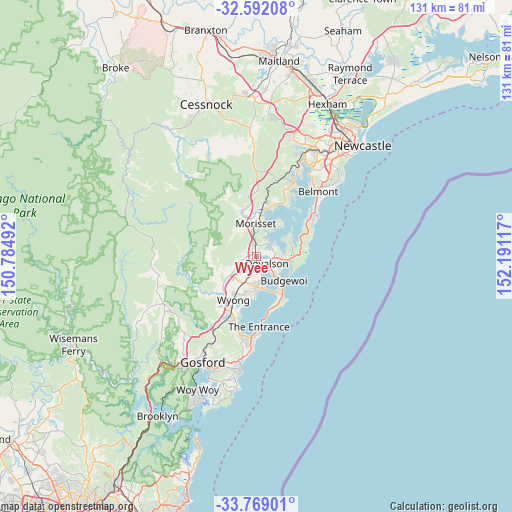
Wyee GPS coordinates[2]
33° 10' 57.072" South, 151° 29' 16.944" East
| Map corner | latitude | longitude |
|---|---|---|
| Upper-left | -32.59208°, | 150.78492° |
| Center: | -33.18252°, | 151.48804° |
| Lower-right: | -33.76901°, | 152.19117° |
| Map W x H: | 130.9×130.9 km | = 81.3×81.3mi |
| max Lat: | -10.58257° ⇑43.7% North |
| Wyee: | -33.18252° |
| min Lat: | ⇓56.3% South -43.31423° |
| min Long | Wyee | max Long |
| 113.53327° | 151.48804° | 153.61246° |
| W 77.6%⇐ | ⇒22.4% E |
Elevation
Elevation of Wyee is 25 m = 82 ft, and this is 97 m = 318 ft below average elevation for this country.
| Max E: |
1715 m = 5627 ft | 67.2% |
| Avg. | 122 m = 400 ft | |
| Wyee | 25 m = 82 ft | |
Min E: |
-2 m = -7 ft | 32.8% |
See also: Australia elevation on elevation.city.
Geographical zone
Wyee is located in South temperate zone (between Tropic of Capricorn and the Antarctic Circle). Distance of this Southern Tropic circle is 1083.6 km =673.3 mi to North.| Distance of | km | miles | from Wyee |
|---|---|---|---|
| Equator | 3689.6 | 2292.6 | to North |
| Tropic Capricorn | 1083.6 | 673.3 | to North |
| Antarctic Circle | 3711.6 | 2306.3 | to South |
| South Pole | 6317.5 | 3925.5 | to South |


Nearby cities:
15 places around Wyee: (largest is in red/bold)
• Blue Haven
3.5 km =2.2 mi,  155°
155°
• Buff Point
6 km =3.7 mi,  138°
138°
• Chain Valley Bay
7.8 km =4.8 mi,  81°
81°
• Charmhaven
5.1 km =3.2 mi, 164°
• Halekulani
7.2 km =4.5 mi,  124°
124°
• Hamlyn Terrace
7.7 km =4.8 mi,  188°
188°
• Jilliby
8.2 km =5.1 mi,  233°
233°
• Kanwal
7.8 km =4.8 mi,  177°
177°
• Lake Haven
6.9 km =4.3 mi,  167°
167°
• Mannering Park
5.1 km =3.2 mi,  58°
58°
• San Remo
4.7 km =2.9 mi, 139°
• Warnervale
7.9 km =4.9 mi,  205°
205°
• Windermere Park
7.9 km =4.9 mi,  30°
30°
• Woongarrah
6.6 km =4.1 mi, 190°
• Wyee Point
4.5 km =2.8 mi,  24°
24°
Sources, notices
• [Note1] Compared only with cities in Australia existing in our database
• [Src1] Map data: © OpenStreetMap contributors (CC-BY-SA)
• [Src2] Other city data from geonames.org with taken over terms of usage.
• [Src3] Geographical zone / Annual Mean Temperature by Robert A. Rohde @ Wikipedia
