Warnervale geodata
Warnervale (New South Wales) is a populated place; located in Australia in Australia/Sydney (GMT+11) time zone. With population of 624 people, there are 4506 cities with bigger population in this country. Compared to other cities in Australia, 55.9% of cities are located further ↓South; 77.3% of cities are located further ←West and 77.5% of cities have higher elevation than Warnervale. Note1


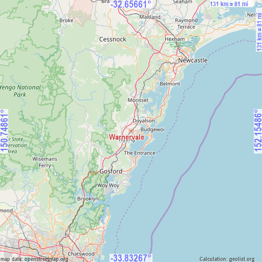
Warnervale GPS coordinates[2]
33° 14' 47.832" South, 151° 27' 6.228" East
| Map corner | latitude | longitude |
|---|---|---|
| Upper-left | -32.65661°, | 150.74861° |
| Center: | -33.24662°, | 151.45173° |
| Lower-right: | -33.83267°, | 152.15486° |
| Map W x H: | 130.8×130.8 km | = 81.3×81.3mi |
| max Lat: | -10.58257° ⇑44.1% North |
| Warnervale: | -33.24662° |
| min Lat: | ⇓55.9% South -43.31423° |
| min Long | Warnervale | max Long |
| 113.53327° | 151.45173° | 153.61246° |
| W 77.3%⇐ | ⇒22.7% E |
Elevation
Elevation of Warnervale is 17 m = 56 ft, and this is 105 m = 344 ft below average elevation for this country.
| Max E: |
1715 m = 5627 ft | 77.5% |
| Avg. | 122 m = 400 ft | |
| Warnervale | 17 m = 56 ft | |
Min E: |
-2 m = -7 ft | 22.5% |
See also: Australia elevation on elevation.city.
Geographical zone
Warnervale is located in South temperate zone (between Tropic of Capricorn and the Antarctic Circle). Distance of this Southern Tropic circle is 1090.8 km =677.8 mi to North.| Distance of | km | miles | from Warnervale |
|---|---|---|---|
| Equator | 3696.7 | 2297 | to North |
| Tropic Capricorn | 1090.8 | 677.8 | to North |
| Antarctic Circle | 3704.5 | 2301.9 | to South |
| South Pole | 6310.4 | 3921.1 | to South |


Nearby cities:
15 places around Warnervale: (largest is in red/bold)
• Blue Haven
6.2 km =3.9 mi,  50°
50°
• Charmhaven
5.2 km =3.2 mi,  65°
65°
• Gorokan
5.5 km =3.4 mi,  102°
102°
• Hamlyn Terrace
2.3 km =1.4 mi, 102°
• Jilliby
4 km =2.5 mi,  305°
305°
• Kanwal
3.7 km =2.3 mi, 100°
• Lake Haven
4.9 km =3 mi,  85°
85°
• Tacoma
4.7 km =2.9 mi,  167°
167°
• Tuggerah
7 km =4.3 mi,  197°
197°
• Tuggerawong
4.6 km =2.9 mi,  144°
144°
• Wadalba
3.1 km =1.9 mi,  156°
156°
• Watanobbi
3.6 km =2.2 mi,  229°
229°
• Woongarrah
2.3 km =1.4 mi,  75°
75°
• Wyong
4.8 km =3 mi,  213°
213°
• Wyongah
4.7 km =2.9 mi,  132°
132°
Sources, notices
• [Note1] Compared only with cities in Australia existing in our database
• [Src1] Map data: © OpenStreetMap contributors (CC-BY-SA)
• [Src2] Other city data from geonames.org with taken over terms of usage.
• [Src3] Geographical zone / Annual Mean Temperature by Robert A. Rohde @ Wikipedia
