Charmhaven geodata
Charmhaven (New South Wales) is a section of populated place; located in Australia in Australia/Sydney (GMT+11) time zone. With population of 2,510 people, there are 2566 cities with bigger population in this country. Compared to other cities in Australia, 56% of cities are located further ↓South; 77.8% of cities are located further ←West and 72.3% of cities have higher elevation than Charmhaven. Note1


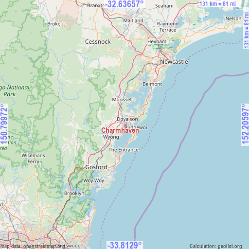
Charmhaven GPS coordinates[2]
33° 13' 36.156" South, 151° 30' 10.224" East
| Map corner | latitude | longitude |
|---|---|---|
| Upper-left | -32.63657°, | 150.79972° |
| Center: | -33.22671°, | 151.50284° |
| Lower-right: | -33.8129°, | 152.20597° |
| Map W x H: | 130.8×130.8 km | = 81.3×81.3mi |
| max Lat: | -10.58257° ⇑44% North |
| Charmhaven: | -33.22671° |
| min Lat: | ⇓56% South -43.31423° |
| min Long | Charmhaven | max Long |
| 113.53327° | 151.50284° | 153.61246° |
| W 77.8%⇐ | ⇒22.2% E |
Elevation
Elevation of Charmhaven is 21 m = 69 ft, and this is 101 m = 331 ft below average elevation for this country.
| Max E: |
1715 m = 5627 ft | 72.3% |
| Avg. | 122 m = 400 ft | |
| Charmhaven | 21 m = 69 ft | |
Min E: |
-2 m = -7 ft | 27.7% |
See also: Australia elevation on elevation.city.
Geographical zone
Charmhaven is located in South temperate zone (between Tropic of Capricorn and the Antarctic Circle). Distance of this Southern Tropic circle is 1088.5 km =676.4 mi to North.| Distance of | km | miles | from Charmhaven |
|---|---|---|---|
| Equator | 3694.5 | 2295.7 | to North |
| Tropic Capricorn | 1088.5 | 676.4 | to North |
| Antarctic Circle | 3706.7 | 2303.2 | to South |
| South Pole | 6312.6 | 3922.5 | to South |


Nearby cities:
15 places around Charmhaven: (largest is in red/bold)
• Blue Haven
1.7 km =1.1 mi,  2°
2°
• Budgewoi
4.8 km =3 mi,  99°
99°
• Buff Point
2.7 km =1.7 mi,  80°
80°
• Gorokan
3.5 km =2.2 mi,  169°
169°
• Halekulani
4.7 km =2.9 mi, 79°
• Hamlyn Terrace
3.7 km =2.3 mi,  222°
222°
• Kanwal
3.1 km =1.9 mi,  200°
200°
• Lake Haven
1.8 km =1.1 mi,  175°
175°
• San Remo
2.2 km =1.4 mi,  51°
51°
• Toukley
5.3 km =3.3 mi,  141°
141°
• Wadalba
6.2 km =3.9 mi,  214°
214°
• Warnervale
5.2 km =3.2 mi,  245°
245°
• Woongarrah
3 km =1.9 mi,  237°
237°
• Wyee
5.1 km =3.2 mi,  344°
344°
• Wyongah
5.5 km =3.4 mi,  193°
193°
Sources, notices
• [Note1] Compared only with cities in Australia existing in our database
• [Src1] Map data: © OpenStreetMap contributors (CC-BY-SA)
• [Src2] Other city data from geonames.org with taken over terms of usage.
• [Src3] Geographical zone / Annual Mean Temperature by Robert A. Rohde @ Wikipedia
