Woombye geodata
Woombye (Queensland) is a section of populated place; located in Australia in Australia/Brisbane (GMT+10) time zone. With population of 3,224 people, there are 2110 cities with bigger population in this country. Compared to other cities in Australia, 86.8% of cities are located further ↓South; 90.1% of cities are located further ←West and 65.9% of cities have higher elevation than Woombye. Note1


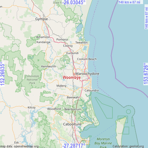
Woombye GPS coordinates[2]
26° 39' 37.944" South, 152° 58' 10.092" East
| Map corner | latitude | longitude |
|---|---|---|
| Upper-left | -26.03045°, | 152.26635° |
| Center: | -26.66054°, | 152.96947° |
| Lower-right: | -27.28717°, | 153.6726° |
| Map W x H: | 139.7×139.7 km | = 86.8×86.8mi |
| max Lat: | -10.58257° ⇑13.2% North |
| Woombye: | -26.66054° |
| min Lat: | ⇓86.8% South -43.31423° |
| min Long | Woombye | max Long |
| 113.53327° | 152.96947° | 153.61246° |
| W 90.1%⇐ | ⇒9.9% E |
Elevation
Elevation of Woombye is 26 m = 85 ft, and this is 96 m = 315 ft below average elevation for this country.
| Max E: |
1715 m = 5627 ft | 65.9% |
| Avg. | 122 m = 400 ft | |
| Woombye | 26 m = 85 ft | |
Min E: |
-2 m = -7 ft | 34.1% |
See also: Australia elevation on elevation.city.
Geographical zone
Woombye is located in South temperate zone (between Tropic of Capricorn and the Antarctic Circle). Distance of this Southern Tropic circle is 358.5 km =222.8 mi to North.| Distance of | km | miles | from Woombye |
|---|---|---|---|
| Equator | 2964.4 | 1842 | to North |
| Tropic Capricorn | 358.5 | 222.8 | to North |
| Antarctic Circle | 4436.8 | 2756.9 | to South |
| South Pole | 7042.7 | 4376.1 | to South |


Nearby cities:
15 places around Woombye: (largest is in red/bold)
• Bli Bli
8.2 km =5.1 mi,  54°
54°
• Burnside
4.2 km =2.6 mi,  317°
317°
• Coes Creek
2.5 km =1.6 mi,  306°
306°
• Diddillibah
8.2 km =5.1 mi,  75°
75°
• Dulong
7 km =4.3 mi,  295°
295°
• Eudlo
7.8 km =4.8 mi,  191°
191°
• Forest Glen
4.7 km =2.9 mi,  131°
131°
• Hunchy
6.2 km =3.9 mi,  249°
249°
• Ilkley
8.3 km =5.2 mi,  160°
160°
• Kiels Mountain
3.9 km =2.4 mi, 83°
• Mons
6.5 km =4 mi,  122°
122°
• Nambour
4 km =2.5 mi,  345°
345°
• Palmwoods
2.9 km =1.8 mi,  196°
196°
• Rosemount
4.5 km =2.8 mi,  41°
41°
• West Woombye
4.4 km =2.7 mi,  261°
261°
Sources, notices
• [Note1] Compared only with cities in Australia existing in our database
• [Src1] Map data: © OpenStreetMap contributors (CC-BY-SA)
• [Src2] Other city data from geonames.org with taken over terms of usage.
• [Src3] Geographical zone / Annual Mean Temperature by Robert A. Rohde @ Wikipedia
