Burnside geodata
Burnside (Queensland) is a section of populated place; located in Australia in Australia/Brisbane (GMT+10) time zone. With population of 2,362 people, there are 2655 cities with bigger population in this country. Compared to other cities in Australia, 87.1% of cities are located further ↓South; 89.3% of cities are located further ←West and 56.9% of cities have higher elevation than Burnside. Note1


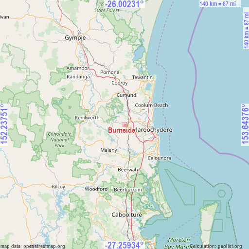
Burnside GPS coordinates[2]
26° 37' 57.18" South, 152° 56' 26.268" East
| Map corner | latitude | longitude |
|---|---|---|
| Upper-left | -26.00231°, | 152.23751° |
| Center: | -26.63255°, | 152.94063° |
| Lower-right: | -27.25934°, | 153.64376° |
| Map W x H: | 139.8×139.8 km | = 86.9×86.9mi |
| max Lat: | -10.58257° ⇑12.9% North |
| Burnside: | -26.63255° |
| min Lat: | ⇓87.1% South -43.31423° |
| min Long | Burnside | max Long |
| 113.53327° | 152.94063° | 153.61246° |
| W 89.3%⇐ | ⇒10.7% E |
Elevation
Elevation of Burnside is 36 m = 118 ft, and this is 86 m = 282 ft below average elevation for this country.
| Max E: |
1715 m = 5627 ft | 56.9% |
| Avg. | 122 m = 400 ft | |
| Burnside | 36 m = 118 ft | |
Min E: |
-2 m = -7 ft | 43.1% |
See also: Australia elevation on elevation.city.
Geographical zone
Burnside is located in South temperate zone (between Tropic of Capricorn and the Antarctic Circle). Distance of this Southern Tropic circle is 355.3 km =220.8 mi to North.| Distance of | km | miles | from Burnside |
|---|---|---|---|
| Equator | 2961.3 | 1840.1 | to North |
| Tropic Capricorn | 355.3 | 220.8 | to North |
| Antarctic Circle | 4439.9 | 2758.8 | to South |
| South Pole | 7045.8 | 4378.1 | to South |


Nearby cities:
15 places around Burnside: (largest is in red/bold)
• Coes Creek
1.8 km =1.1 mi,  151°
151°
• Dulong
3.4 km =2.1 mi,  267°
267°
• Flaxton
8.1 km =5 mi,  250°
250°
• Forest Glen
8.9 km =5.5 mi,  134°
134°
• Hunchy
6 km =3.7 mi,  209°
209°
• Kiels Mountain
7.2 km =4.5 mi,  111°
111°
• Kureelpa
5.7 km =3.5 mi,  300°
300°
• Mapleton
7.3 km =4.5 mi,  277°
277°
• Montville
8 km =5 mi,  225°
225°
• Nambour
2 km =1.2 mi,  69°
69°
• Palmwoods
6.3 km =3.9 mi,  160°
160°
• Rosemount
5.9 km =3.7 mi,  87°
87°
• West Woombye
4.1 km =2.5 mi,  201°
201°
• Woombye
4.2 km =2.6 mi,  137°
137°
• Yandina
8 km =5 mi,  10°
10°
Sources, notices
• [Note1] Compared only with cities in Australia existing in our database
• [Src1] Map data: © OpenStreetMap contributors (CC-BY-SA)
• [Src2] Other city data from geonames.org with taken over terms of usage.
• [Src3] Geographical zone / Annual Mean Temperature by Robert A. Rohde @ Wikipedia
