Palmwoods geodata
Palmwoods (Queensland) is a section of populated place; located in Australia in Australia/Brisbane (GMT+10) time zone. With population of 5,575 people, there are 1320 cities with bigger population in this country. Compared to other cities in Australia, 86.7% of cities are located further ↓South; 89.9% of cities are located further ←West and 58.4% of cities have higher elevation than Palmwoods. Note1


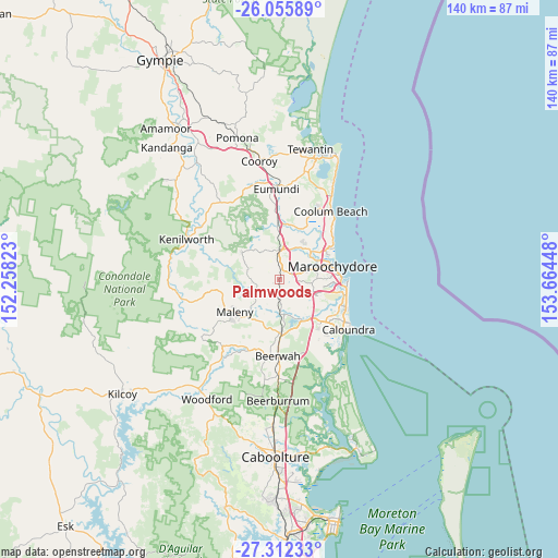
Palmwoods GPS coordinates[2]
26° 41' 9.024" South, 152° 57' 40.86" East
| Map corner | latitude | longitude |
|---|---|---|
| Upper-left | -26.05589°, | 152.25823° |
| Center: | -26.68584°, | 152.96135° |
| Lower-right: | -27.31233°, | 153.66448° |
| Map W x H: | 139.7×139.7 km | = 86.8×86.8mi |
| max Lat: | -10.58257° ⇑13.3% North |
| Palmwoods: | -26.68584° |
| min Lat: | ⇓86.7% South -43.31423° |
| min Long | Palmwoods | max Long |
| 113.53327° | 152.96135° | 153.61246° |
| W 89.9%⇐ | ⇒10.1% E |
Elevation
Elevation of Palmwoods is 34 m = 112 ft, and this is 88 m = 289 ft below average elevation for this country.
| Max E: |
1715 m = 5627 ft | 58.4% |
| Avg. | 122 m = 400 ft | |
| Palmwoods | 34 m = 112 ft | |
Min E: |
-2 m = -7 ft | 41.6% |
See also: Australia elevation on elevation.city.
Geographical zone
Palmwoods is located in South temperate zone (between Tropic of Capricorn and the Antarctic Circle). Distance of this Southern Tropic circle is 361.3 km =224.5 mi to North.| Distance of | km | miles | from Palmwoods |
|---|---|---|---|
| Equator | 2967.2 | 1843.7 | to North |
| Tropic Capricorn | 361.3 | 224.5 | to North |
| Antarctic Circle | 4434 | 2755.2 | to South |
| South Pole | 7039.9 | 4374.4 | to South |


Nearby cities:
15 places around Palmwoods: (largest is in red/bold)
• Burnside
6.3 km =3.9 mi,  340°
340°
• Coes Creek
4.5 km =2.8 mi, 344°
• Dulong
8 km =5 mi,  316°
316°
• Eudlo
4.9 km =3 mi,  188°
188°
• Forest Glen
4.3 km =2.7 mi,  94°
94°
• Hunchy
5.1 km =3.2 mi,  277°
277°
• Ilkley
6.2 km =3.9 mi,  144°
144°
• Kiels Mountain
5.7 km =3.5 mi,  54°
54°
• Mons
6.4 km =4 mi,  95°
95°
• Montville
7.8 km =4.8 mi,  272°
272°
• Nambour
6.6 km =4.1 mi,  358°
358°
• Rosemount
7.3 km =4.5 mi,  31°
31°
• Tanawha
7.8 km =4.8 mi,  118°
118°
• West Woombye
4.2 km =2.6 mi,  301°
301°
• Woombye
2.9 km =1.8 mi,  16°
16°
Sources, notices
• [Note1] Compared only with cities in Australia existing in our database
• [Src1] Map data: © OpenStreetMap contributors (CC-BY-SA)
• [Src2] Other city data from geonames.org with taken over terms of usage.
• [Src3] Geographical zone / Annual Mean Temperature by Robert A. Rohde @ Wikipedia
