Woolloomooloo geodata
Woolloomooloo (New South Wales) is a section of populated place; located in Australia in Australia/Sydney (GMT+11) time zone. With population of 4,174 people, there are 1728 cities with bigger population in this country. Compared to other cities in Australia, 54.6% of cities are located further ↑North; 73.8% of cities are located further ←West and 95.5% of cities have higher elevation than Woolloomooloo. Note1


Woolloomooloo GPS coordinates[2]
33° 52' 13.512" South, 151° 13' 10.848" East
| Map corner | latitude | longitude |
|---|---|---|
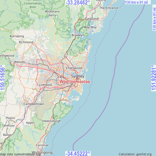
| Upper-left | -33.28462°, | 150.51656° |
| Center: | -33.87042°, | 151.21968° |
| Lower-right: | -34.45222°, | 151.92281° |
| Map W x H: | 129.8×129.8 km | = 80.7×80.7mi |
| max Lat: | -10.58257° ⇑54.6% North |
| Woolloomooloo: | -33.87042° |
| min Lat: | ⇓45.4% South -43.31423° |
| min Long | Woolloomooloo | max Long |
| 113.53327° | 151.21968° | 153.61246° |
| W 73.8%⇐ | ⇒26.2% E |
Elevation
Elevation of Woolloomooloo is 6 m = 20 ft, and this is 116 m = 381 ft below average elevation for this country.
| Max E: |
1715 m = 5627 ft | 95.5% |
| Avg. | 122 m = 400 ft | |
| Woolloomooloo | 6 m = 20 ft | |
Min E: |
-2 m = -7 ft | 4.5% |
See also: Australia elevation on elevation.city.
Geographical zone
Woolloomooloo is located in South temperate zone (between Tropic of Capricorn and the Antarctic Circle). Distance of this Southern Tropic circle is 1160.1 km =720.9 mi to North.| Distance of | km | miles | from Woolloomooloo |
|---|---|---|---|
| Equator | 3766 | 2340.1 | to North |
| Tropic Capricorn | 1160.1 | 720.9 | to North |
| Antarctic Circle | 3635.1 | 2258.7 | to South |
| South Pole | 6241 | 3878 | to South |


Nearby cities:
15 places around Woolloomooloo: (largest is in red/bold)
• Darling Point
1.8 km =1.1 mi,  90°
90°
• Darlinghurst
1 km =0.6 mi,  182°
182°
• Double Bay
2.4 km =1.5 mi,  110°
110°
• Edgecliff
1.9 km =1.2 mi,  122°
122°
• Elizabeth Bay
0.7 km =0.4 mi,  102°
102°
• Haymarket
1.6 km =1 mi,  235°
235°
• Millers Point
1.9 km =1.2 mi,  309°
309°
• Paddington
1.9 km =1.2 mi,  144°
144°
• Potts Point
0.7 km =0.4 mi,  56°
56°
• Rushcutters Bay
0.9 km =0.6 mi, 122°
• Surry Hills
1.6 km =1 mi,  203°
203°
• Sydney
1.2 km =0.7 mi,  284°
284°
• Sydney Central Business District
1.3 km =0.8 mi,  299°
299°
• The Rocks
1.6 km =1 mi,  319°
319°
• Ultimo
2.2 km =1.4 mi,  249°
249°
Sources, notices
• [Note1] Compared only with cities in Australia existing in our database
• [Src1] Map data: © OpenStreetMap contributors (CC-BY-SA)
• [Src2] Other city data from geonames.org with taken over terms of usage.
• [Src3] Geographical zone / Annual Mean Temperature by Robert A. Rohde @ Wikipedia
