Edgecliff geodata
Edgecliff (New South Wales) is a section of populated place; located in Australia in Australia/Sydney (GMT+11) time zone. With population of 2,670 people, there are 2452 cities with bigger population in this country. Compared to other cities in Australia, 55% of cities are located further ↑North; 74.3% of cities are located further ←West and 52% of cities have lower elevation than Edgecliff. Note1


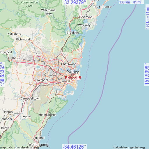
Edgecliff GPS coordinates[2]
33° 52' 46.272" South, 151° 14' 12.372" East
| Map corner | latitude | longitude |
|---|---|---|
| Upper-left | -33.29379°, | 150.53365° |
| Center: | -33.87952°, | 151.23677° |
| Lower-right: | -34.46126°, | 151.9399° |
| Map W x H: | 129.8×129.8 km | = 80.7×80.7mi |
| max Lat: | -10.58257° ⇑55% North |
| Edgecliff: | -33.87952° |
| min Lat: | ⇓45% South -43.31423° |
| min Long | Edgecliff | max Long |
| 113.53327° | 151.23677° | 153.61246° |
| W 74.3%⇐ | ⇒25.7% E |
Elevation
Elevation of Edgecliff is 48 m = 157 ft, and this is 74 m = 243 ft below average elevation for this country.
| Max E: |
1715 m = 5627 ft | 48% |
| Avg. | 122 m = 400 ft | |
| Edgecliff | 48 m = 157 ft | |
Min E: |
-2 m = -7 ft | 52% |
See also: Australia elevation on elevation.city.
Geographical zone
Edgecliff is located in South temperate zone (between Tropic of Capricorn and the Antarctic Circle). Distance of this Southern Tropic circle is 1161.1 km =721.5 mi to North.| Distance of | km | miles | from Edgecliff |
|---|---|---|---|
| Equator | 3767 | 2340.7 | to North |
| Tropic Capricorn | 1161.1 | 721.5 | to North |
| Antarctic Circle | 3634.1 | 2258.1 | to South |
| South Pole | 6240 | 3877.4 | to South |


Nearby cities:
15 places around Edgecliff: (largest is in red/bold)
• Bellevue Hill
1.3 km =0.8 mi,  87°
87°
• Bondi Junction
1.8 km =1.1 mi,  146°
146°
• Centennial Park
2.1 km =1.3 mi,  188°
188°
• Darling Point
1 km =0.6 mi,  11°
11°
• Darlinghurst
1.6 km =1 mi,  270°
270°
• Double Bay
0.7 km =0.4 mi,  73°
73°
• Elizabeth Bay
1.2 km =0.7 mi,  313°
313°
• Paddington
0.7 km =0.4 mi,  223°
223°
• Point Piper
1.9 km =1.2 mi,  40°
40°
• Potts Point
1.7 km =1.1 mi,  324°
324°
• Queens Park
2.4 km =1.5 mi,  156°
156°
• Rushcutters Bay
1 km =0.6 mi,  302°
302°
• Surry Hills
2.3 km =1.4 mi,  258°
258°
• Woollahra
0.9 km =0.6 mi,  179°
179°
• Woolloomooloo
1.9 km =1.2 mi, 302°
Sources, notices
• [Note1] Compared only with cities in Australia existing in our database
• [Src1] Map data: © OpenStreetMap contributors (CC-BY-SA)
• [Src2] Other city data from geonames.org with taken over terms of usage.
• [Src3] Geographical zone / Annual Mean Temperature by Robert A. Rohde @ Wikipedia
