Haymarket geodata
Haymarket (New South Wales) is a section of populated place; located in Australia in Australia/Sydney (GMT+10) time zone. With population of 9,587 people, there are 641 cities with bigger population in this country. Compared to other cities in Australia, 54.9% of cities are located further ↑North; 73.4% of cities are located further ←West and 68.6% of cities have higher elevation than Haymarket. Note1


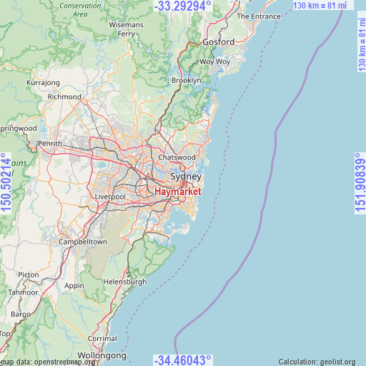
Haymarket GPS coordinates[2]
33° 52' 43.248" South, 151° 12' 18.936" East
| Map corner | latitude | longitude |
|---|---|---|
| Upper-left | -33.29294°, | 150.50214° |
| Center: | -33.87868°, | 151.20526° |
| Lower-right: | -34.46043°, | 151.90839° |
| Map W x H: | 129.8×129.8 km | = 80.7×80.7mi |
| max Lat: | -10.58257° ⇑54.9% North |
| Haymarket: | -33.87868° |
| min Lat: | ⇓45.1% South -43.31423° |
| min Long | Haymarket | max Long |
| 113.53327° | 151.20526° | 153.61246° |
| W 73.4%⇐ | ⇒26.6% E |
Elevation
Elevation of Haymarket is 24 m = 79 ft, and this is 98 m = 322 ft below average elevation for this country.
| Max E: |
1715 m = 5627 ft | 68.6% |
| Avg. | 122 m = 400 ft | |
| Haymarket | 24 m = 79 ft | |
Min E: |
-2 m = -7 ft | 31.4% |
See also: Australia elevation on elevation.city.
Geographical zone
Haymarket is located in South temperate zone (between Tropic of Capricorn and the Antarctic Circle). Distance of this Southern Tropic circle is 1161 km =721.4 mi to North.| Distance of | km | miles | from Haymarket |
|---|---|---|---|
| Equator | 3767 | 2340.7 | to North |
| Tropic Capricorn | 1161 | 721.4 | to North |
| Antarctic Circle | 3634.2 | 2258.2 | to South |
| South Pole | 6240.1 | 3877.4 | to South |


Nearby cities:
15 places around Haymarket: (largest is in red/bold)
• Chippendale
1.1 km =0.7 mi,  218°
218°
• Darlinghurst
1.3 km =0.8 mi,  93°
93°
• Darlington
1.6 km =1 mi,  213°
213°
• Elizabeth Bay
2.2 km =1.4 mi,  69°
69°
• Glebe
1.9 km =1.2 mi,  269°
269°
• Millers Point
2.1 km =1.3 mi,  357°
357°
• Pyrmont
1.4 km =0.9 mi,  313°
313°
• Redfern
1.6 km =1 mi,  183°
183°
• Rushcutters Bay
2.1 km =1.3 mi,  78°
78°
• Surry Hills
0.9 km =0.6 mi,  128°
128°
• Sydney
1.2 km =0.7 mi,  8°
8°
• Sydney Central Business District
1.6 km =1 mi, 8°
• The Rocks
2.2 km =1.4 mi, 6°
• Ultimo
0.8 km =0.5 mi,  282°
282°
• Woolloomooloo
1.6 km =1 mi,  55°
55°
Sources, notices
• [Note1] Compared only with cities in Australia existing in our database
• [Src1] Map data: © OpenStreetMap contributors (CC-BY-SA)
• [Src2] Other city data from geonames.org with taken over terms of usage.
• [Src3] Geographical zone / Annual Mean Temperature by Robert A. Rohde @ Wikipedia
