Woolamia geodata
Woolamia (New South Wales) is a populated place; located in Australia in Australia/Sydney (GMT+11) time zone. With population of 567 people, there are 4658 cities with bigger population in this country. Compared to other cities in Australia, 71.8% of cities are located further ↑North; 60.2% of cities are located further ←West and 77.5% of cities have higher elevation than Woolamia. Note1


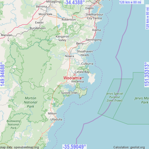
Woolamia GPS coordinates[2]
35° 1' 0.012" South, 150° 39' 0" East
| Map corner | latitude | longitude |
|---|---|---|
| Upper-left | -34.4388°, | 149.94688° |
| Center: | -35.01667°, | 150.65° |
| Lower-right: | -35.59049°, | 151.35313° |
| Map W x H: | 128.1×128.1 km | = 79.6×79.6mi |
| max Lat: | -10.58257° ⇑71.8% North |
| Woolamia: | -35.01667° |
| min Lat: | ⇓28.2% South -43.31423° |
| min Long | Woolamia | max Long |
| 113.53327° | 150.65° | 153.61246° |
| W 60.2%⇐ | ⇒39.8% E |
Elevation
Elevation of Woolamia is 17 m = 56 ft, and this is 105 m = 344 ft below average elevation for this country.
| Max E: |
1715 m = 5627 ft | 77.5% |
| Avg. | 122 m = 400 ft | |
| Woolamia | 17 m = 56 ft | |
Min E: |
-2 m = -7 ft | 22.5% |
See also: Australia elevation on elevation.city.
Geographical zone
Woolamia is located in South temperate zone (between Tropic of Capricorn and the Antarctic Circle). Distance of this Southern Tropic circle is 1287.6 km =800.1 mi to North.| Distance of | km | miles | from Woolamia |
|---|---|---|---|
| Equator | 3893.5 | 2419.3 | to North |
| Tropic Capricorn | 1287.6 | 800.1 | to North |
| Antarctic Circle | 3507.7 | 2179.6 | to South |
| South Pole | 6113.6 | 3798.8 | to South |


Nearby cities:
15 places around Woolamia: (largest is in red/bold)
• Basin View
11.7 km =7.3 mi,  227°
227°
• Callala Bay
7 km =4.3 mi,  71°
71°
• Callala Beach
4.4 km =2.7 mi, 73°
• Erowal Bay
9.3 km =5.8 mi,  179°
179°
• Falls Creek
7.2 km =4.5 mi,  320°
320°
• Huskisson
3.1 km =1.9 mi,  147°
147°
• Jervis Bay Village
13.3 km =8.3 mi,  158°
158°
• Nowra Hill
12.1 km =7.5 mi, 324°
• Old Erowal Bay
7.6 km =4.7 mi, 182°
• Sanctuary Point
9.9 km =6.2 mi,  192°
192°
• South Nowra
13.5 km =8.4 mi,  339°
339°
• St. Georges Basin
9.4 km =5.8 mi,  210°
210°
• Tomerong
7 km =4.3 mi,  235°
235°
• Vincentia
6.2 km =3.9 mi, 158°
• Worrigee
13.1 km =8.1 mi,  353°
353°
Sources, notices
• [Note1] Compared only with cities in Australia existing in our database
• [Src1] Map data: © OpenStreetMap contributors (CC-BY-SA)
• [Src2] Other city data from geonames.org with taken over terms of usage.
• [Src3] Geographical zone / Annual Mean Temperature by Robert A. Rohde @ Wikipedia
