Falls Creek geodata
Falls Creek (New South Wales) is a populated place; located in Australia in Australia/Sydney (GMT+11) time zone. With population of 911 people, there are 3964 cities with bigger population in this country. Compared to other cities in Australia, 70.5% of cities are located further ↑North; 59.6% of cities are located further ←West and 52% of cities have lower elevation than Falls Creek. Note1


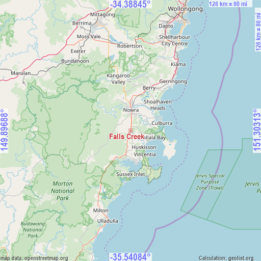
Falls Creek GPS coordinates[2]
34° 58' 0.012" South, 150° 36' 0" East
| Map corner | latitude | longitude |
|---|---|---|
| Upper-left | -34.38845°, | 149.89688° |
| Center: | -34.96667°, | 150.6° |
| Lower-right: | -35.54084°, | 151.30313° |
| Map W x H: | 128.1×128.1 km | = 79.6×79.6mi |
| max Lat: | -10.58257° ⇑70.5% North |
| Falls Creek: | -34.96667° |
| min Lat: | ⇓29.5% South -43.31423° |
| min Long | Falls Creek | max Long |
| 113.53327° | 150.6° | 153.61246° |
| W 59.6%⇐ | ⇒40.4% E |
Elevation
Elevation of Falls Creek is 48 m = 157 ft, and this is 74 m = 243 ft below average elevation for this country.
| Max E: |
1715 m = 5627 ft | 48% |
| Avg. | 122 m = 400 ft | |
| Falls Creek | 48 m = 157 ft | |
Min E: |
-2 m = -7 ft | 52% |
See also: Australia elevation on elevation.city.
Geographical zone
Falls Creek is located in South temperate zone (between Tropic of Capricorn and the Antarctic Circle). Distance of this Southern Tropic circle is 1282 km =796.6 mi to North.| Distance of | km | miles | from Falls Creek |
|---|---|---|---|
| Equator | 3887.9 | 2415.8 | to North |
| Tropic Capricorn | 1282 | 796.6 | to North |
| Antarctic Circle | 3513.2 | 2183 | to South |
| South Pole | 6119.1 | 3802.2 | to South |


Nearby cities:
15 places around Falls Creek: (largest is in red/bold)
• Bomaderry
13 km =8.1 mi,  4°
4°
• Callala Bay
11.7 km =7.3 mi,  106°
106°
• Callala Beach
9.7 km =6 mi,  116°
116°
• Greenwell Point
13.6 km =8.5 mi,  61°
61°
• Huskisson
10.2 km =6.3 mi,  142°
142°
• North Nowra
12.3 km =7.6 mi,  349°
349°
• Nowra
9.2 km =5.7 mi, 0°
• Nowra Hill
4.9 km =3 mi,  329°
329°
• South Nowra
7 km =4.3 mi,  358°
358°
• St. Georges Basin
13.7 km =8.5 mi,  180°
180°
• Tomerong
9.6 km =6 mi,  187°
187°
• Vincentia
13.2 km =8.2 mi,  148°
148°
• West Nowra
9.1 km =5.7 mi, 350°
• Woolamia
7.2 km =4.5 mi, 140°
• Worrigee
8 km =5 mi,  22°
22°
Sources, notices
• [Note1] Compared only with cities in Australia existing in our database
• [Src1] Map data: © OpenStreetMap contributors (CC-BY-SA)
• [Src2] Other city data from geonames.org with taken over terms of usage.
• [Src3] Geographical zone / Annual Mean Temperature by Robert A. Rohde @ Wikipedia
