Vincentia geodata
Vincentia (New South Wales) is a populated place; located in Australia in Australia/Sydney (GMT+11) time zone. With population of 3,150 people, there are 2159 cities with bigger population in this country. Compared to other cities in Australia, 72.7% of cities are located further ↑North; 60.4% of cities are located further ←West and 85% of cities have higher elevation than Vincentia. Note1


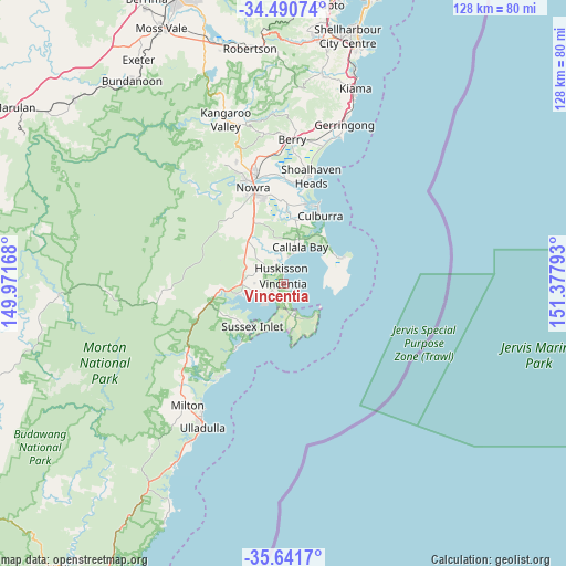
Vincentia GPS coordinates[2]
35° 4' 5.7" South, 150° 40' 29.28" East
| Map corner | latitude | longitude |
|---|---|---|
| Upper-left | -34.49074°, | 149.97168° |
| Center: | -35.06825°, | 150.6748° |
| Lower-right: | -35.6417°, | 151.37793° |
| Map W x H: | 128×128 km | = 79.5×79.5mi |
| max Lat: | -10.58257° ⇑72.7% North |
| Vincentia: | -35.06825° |
| min Lat: | ⇓27.3% South -43.31423° |
| min Long | Vincentia | max Long |
| 113.53327° | 150.6748° | 153.61246° |
| W 60.4%⇐ | ⇒39.6% E |
Elevation
Elevation of Vincentia is 12 m = 39 ft, and this is 110 m = 361 ft below average elevation for this country.
| Max E: |
1715 m = 5627 ft | 85% |
| Avg. | 122 m = 400 ft | |
| Vincentia | 12 m = 39 ft | |
Min E: |
-2 m = -7 ft | 15% |
See also: Australia elevation on elevation.city.
Geographical zone
Vincentia is located in South temperate zone (between Tropic of Capricorn and the Antarctic Circle). Distance of this Southern Tropic circle is 1293.3 km =803.6 mi to North.| Distance of | km | miles | from Vincentia |
|---|---|---|---|
| Equator | 3899.2 | 2422.8 | to North |
| Tropic Capricorn | 1293.3 | 803.6 | to North |
| Antarctic Circle | 3502 | 2176 | to South |
| South Pole | 6107.8 | 3795.2 | to South |


Nearby cities:
15 places around Vincentia: (largest is in red/bold)
• Basin View
11.1 km =6.9 mi,  258°
258°
• Callala Bay
9.1 km =5.7 mi,  28°
28°
• Callala Beach
7.2 km =4.5 mi,  15°
15°
• Culburra Beach
17.3 km =10.7 mi, 25°
• Erowal Bay
4.2 km =2.6 mi,  212°
212°
• Falls Creek
13.2 km =8.2 mi,  328°
328°
• Huskisson
3.2 km =2 mi,  348°
348°
• Jervis Bay Village
7.2 km =4.5 mi,  158°
158°
• Nowra Hill
18.1 km =11.2 mi, 329°
• Old Erowal Bay
3.2 km =2 mi,  235°
235°
• Sanctuary Point
5.9 km =3.7 mi,  228°
228°
• St. Georges Basin
7.4 km =4.6 mi,  251°
251°
• Sussex Inlet
12.8 km =8 mi,  219°
219°
• Tomerong
8.2 km =5.1 mi,  282°
282°
• Woolamia
6.2 km =3.9 mi,  338°
338°
Sources, notices
• [Note1] Compared only with cities in Australia existing in our database
• [Src1] Map data: © OpenStreetMap contributors (CC-BY-SA)
• [Src2] Other city data from geonames.org with taken over terms of usage.
• [Src3] Geographical zone / Annual Mean Temperature by Robert A. Rohde @ Wikipedia
