Westmead geodata
Westmead (New South Wales) is a section of populated place; located in Australia in Australia/Sydney (GMT+11) time zone. With population of 17,835 people, there are 201 cities with bigger population in this country. Compared to other cities in Australia, 52.1% of cities are located further ↑North; 67.3% of cities are located further ←West and 56.9% of cities have higher elevation than Westmead. Note1


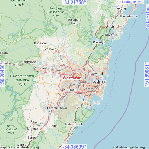
Westmead GPS coordinates[2]
33° 48' 13.788" South, 150° 59' 15.648" East
| Map corner | latitude | longitude |
|---|---|---|
| Upper-left | -33.21758°, | 150.28456° |
| Center: | -33.80383°, | 150.98768° |
| Lower-right: | -34.38609°, | 151.69081° |
| Map W x H: | 129.9×129.9 km | = 80.7×80.7mi |
| max Lat: | -10.58257° ⇑52.1% North |
| Westmead: | -33.80383° |
| min Lat: | ⇓47.9% South -43.31423° |
| min Long | Westmead | max Long |
| 113.53327° | 150.98768° | 153.61246° |
| W 67.3%⇐ | ⇒32.7% E |
Elevation
Elevation of Westmead is 36 m = 118 ft, and this is 86 m = 282 ft below average elevation for this country.
| Max E: |
1715 m = 5627 ft | 56.9% |
| Avg. | 122 m = 400 ft | |
| Westmead | 36 m = 118 ft | |
Min E: |
-2 m = -7 ft | 43.1% |
See also: Australia elevation on elevation.city.
Geographical zone
Westmead is located in South temperate zone (between Tropic of Capricorn and the Antarctic Circle). Distance of this Southern Tropic circle is 1152.7 km =716.3 mi to North.| Distance of | km | miles | from Westmead |
|---|---|---|---|
| Equator | 3758.6 | 2335.5 | to North |
| Tropic Capricorn | 1152.7 | 716.3 | to North |
| Antarctic Circle | 3642.5 | 2263.3 | to South |
| South Pole | 6248.4 | 3882.6 | to South |


Nearby cities:
15 places around Westmead: (largest is in red/bold)
• Constitution Hill
1.6 km =1 mi,  319°
319°
• Harris Park
2.8 km =1.7 mi,  138°
138°
• Holroyd
3.1 km =1.9 mi,  163°
163°
• Mays Hill
1.9 km =1.2 mi, 161°
• Merrylands
3.3 km =2.1 mi,  186°
186°
• Merrylands West
3.6 km =2.2 mi,  208°
208°
• North Parramatta
1.7 km =1.1 mi,  47°
47°
• Northmead
2.4 km =1.5 mi,  24°
24°
• Oatlands
3.7 km =2.3 mi,  76°
76°
• Old Toongabbie
2.5 km =1.6 mi, 316°
• Parramatta
2.1 km =1.3 mi, 136°
• Pendle Hill
3 km =1.9 mi,  269°
269°
• South Wentworthville
2.8 km =1.7 mi,  233°
233°
• Wentworthville
1.9 km =1.2 mi,  260°
260°
• Winston Hills
3.1 km =1.9 mi,  347°
347°
Sources, notices
• [Note1] Compared only with cities in Australia existing in our database
• [Src1] Map data: © OpenStreetMap contributors (CC-BY-SA)
• [Src2] Other city data from geonames.org with taken over terms of usage.
• [Src3] Geographical zone / Annual Mean Temperature by Robert A. Rohde @ Wikipedia
