Holroyd geodata
Holroyd (New South Wales) is a section of populated place; located in Australia in Australia/Sydney (GMT+11) time zone. With population of 1,279 people, there are 3491 cities with bigger population in this country. Compared to other cities in Australia, 52.8% of cities are located further ↑North; 67.5% of cities are located further ←West and 80.4% of cities have higher elevation than Holroyd. Note1


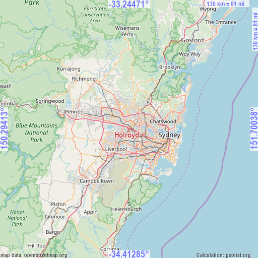
Holroyd GPS coordinates[2]
33° 49' 50.808" South, 150° 59' 50.1" East
| Map corner | latitude | longitude |
|---|---|---|
| Upper-left | -33.24471°, | 150.29413° |
| Center: | -33.83078°, | 150.99725° |
| Lower-right: | -34.41285°, | 151.70038° |
| Map W x H: | 129.9×129.9 km | = 80.7×80.7mi |
| max Lat: | -10.58257° ⇑52.8% North |
| Holroyd: | -33.83078° |
| min Lat: | ⇓47.2% South -43.31423° |
| min Long | Holroyd | max Long |
| 113.53327° | 150.99725° | 153.61246° |
| W 67.5%⇐ | ⇒32.5% E |
Elevation
Elevation of Holroyd is 15 m = 49 ft, and this is 107 m = 351 ft below average elevation for this country.
| Max E: |
1715 m = 5627 ft | 80.4% |
| Avg. | 122 m = 400 ft | |
| Holroyd | 15 m = 49 ft | |
Min E: |
-2 m = -7 ft | 19.6% |
See also: Australia elevation on elevation.city.
Geographical zone
Holroyd is located in South temperate zone (between Tropic of Capricorn and the Antarctic Circle). Distance of this Southern Tropic circle is 1155.7 km =718.1 mi to North.| Distance of | km | miles | from Holroyd |
|---|---|---|---|
| Equator | 3761.6 | 2337.3 | to North |
| Tropic Capricorn | 1155.7 | 718.1 | to North |
| Antarctic Circle | 3639.5 | 2261.5 | to South |
| South Pole | 6245.4 | 3880.7 | to South |


Nearby cities:
15 places around Holroyd: (largest is in red/bold)
• Auburn
4 km =2.5 mi,  122°
122°
• Granville
1.4 km =0.9 mi,  139°
139°
• Guildford West
3.6 km =2.2 mi,  235°
235°
• Harris Park
1.3 km =0.8 mi,  47°
47°
• Mays Hill
1.2 km =0.7 mi,  346°
346°
• Merrylands
1.3 km =0.8 mi,  257°
257°
• Merrylands West
2.6 km =1.6 mi,  265°
265°
• Old Guildford
3.9 km =2.4 mi,  198°
198°
• Parramatta
1.6 km =1 mi,  21°
21°
• Rosehill
2.8 km =1.7 mi,  64°
64°
• South Granville
3.3 km =2.1 mi,  158°
158°
• South Wentworthville
3.4 km =2.1 mi,  293°
293°
• Wentworthville
3.8 km =2.4 mi,  314°
314°
• Westmead
3.1 km =1.9 mi,  343°
343°
• Woodpark
3.6 km =2.2 mi,  250°
250°
Sources, notices
• [Note1] Compared only with cities in Australia existing in our database
• [Src1] Map data: © OpenStreetMap contributors (CC-BY-SA)
• [Src2] Other city data from geonames.org with taken over terms of usage.
• [Src3] Geographical zone / Annual Mean Temperature by Robert A. Rohde @ Wikipedia
