Parramatta geodata
Parramatta (New South Wales) is a seat of a second-order administrative division; located in Australia in Australia/Sydney (GMT+11) time zone. With population of 26,876 people, there are 84 cities with bigger population in this country. Compared to other cities in Australia, 52.5% of cities are located further ↑North; 67.6% of cities are located further ←West and 65.9% of cities have higher elevation than Parramatta. Note1


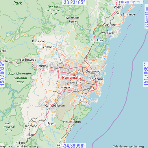
Parramatta GPS coordinates[2]
33° 49' 4.08" South, 151° 0' 12.528" East
| Map corner | latitude | longitude |
|---|---|---|
| Upper-left | -33.23165°, | 150.30036° |
| Center: | -33.8178°, | 151.00348° |
| Lower-right: | -34.39996°, | 151.70661° |
| Map W x H: | 129.9×129.9 km | = 80.7×80.7mi |
| max Lat: | -10.58257° ⇑52.5% North |
| Parramatta: | -33.8178° |
| min Lat: | ⇓47.5% South -43.31423° |
| min Long | Parramatta | max Long |
| 113.53327° | 151.00348° | 153.61246° |
| W 67.6%⇐ | ⇒32.4% E |
Elevation
Elevation of Parramatta is 26 m = 85 ft, and this is 96 m = 315 ft below average elevation for this country.
| Max E: |
1715 m = 5627 ft | 65.9% |
| Avg. | 122 m = 400 ft | |
| Parramatta | 26 m = 85 ft | |
Min E: |
-2 m = -7 ft | 34.1% |
See also: Australia elevation on elevation.city.
Geographical zone
Parramatta is located in South temperate zone (between Tropic of Capricorn and the Antarctic Circle). Distance of this Southern Tropic circle is 1154.3 km =717.2 mi to North.| Distance of | km | miles | from Parramatta |
|---|---|---|---|
| Equator | 3760.2 | 2336.5 | to North |
| Tropic Capricorn | 1154.3 | 717.2 | to North |
| Antarctic Circle | 3641 | 2262.4 | to South |
| South Pole | 6246.9 | 3881.6 | to South |


Nearby cities:
15 places around Parramatta: (largest is in red/bold)
• Constitution Hill
3.8 km =2.4 mi,  318°
318°
• Granville
2.6 km =1.6 mi,  171°
171°
• Harris Park
0.7 km =0.4 mi,  144°
144°
• Holroyd
1.6 km =1 mi,  201°
201°
• Mays Hill
0.9 km =0.6 mi,  251°
251°
• Merrylands
2.5 km =1.6 mi,  227°
227°
• Merrylands West
3.6 km =2.2 mi,  242°
242°
• North Parramatta
2.7 km =1.7 mi,  355°
355°
• Northmead
3.8 km =2.4 mi,  353°
353°
• Oatlands
3.3 km =2.1 mi,  41°
41°
• Rosehill
2 km =1.2 mi,  97°
97°
• Rydalmere
3.2 km =2 mi,  83°
83°
• South Wentworthville
3.7 km =2.3 mi,  268°
268°
• Wentworthville
3.5 km =2.2 mi,  290°
290°
• Westmead
2.1 km =1.3 mi, 316°
Sources, notices
• [Note1] Compared only with cities in Australia existing in our database
• [Src1] Map data: © OpenStreetMap contributors (CC-BY-SA)
• [Src2] Other city data from geonames.org with taken over terms of usage.
• [Src3] Geographical zone / Annual Mean Temperature by Robert A. Rohde @ Wikipedia
