Invermay geodata
Invermay (Victoria) is a populated place; located in Australia in Australia/Melbourne (GMT+11) time zone. With population of 783 people, there are 4176 cities with bigger population in this country. Compared to other cities in Australia, 82.6% of cities are located further ↑North; 72.7% of cities are located further →East and 93.1% of cities have lower elevation than Invermay. Note1


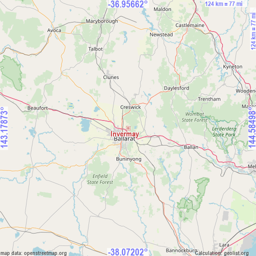
Invermay GPS coordinates[2]
37° 30' 59.04" South, 143° 52' 54.66" East
| Map corner | latitude | longitude |
|---|---|---|
| Upper-left | -36.95662°, | 143.17873° |
| Center: | -37.5164°, | 143.88185° |
| Lower-right: | -38.07202°, | 144.58498° |
| Map W x H: | 124×124 km | = 77.1×77.1mi |
| max Lat: | -10.58257° ⇑82.6% North |
| Invermay: | -37.5164° |
| min Lat: | ⇓17.4% South -43.31423° |
| min Long | Invermay | max Long |
| 113.53327° | 143.88185° | 153.61246° |
| W 27.3%⇐ | ⇒72.7% E |
Elevation
Elevation of Invermay is 475 m = 1558 ft, and this is 353 m = 1158 ft above average elevation for this country.
| Max E: |
1715 m = 5627 ft | 6.9% |
| Invermay | 475 m 1558 ft | |
| Avg. | 122 m = 400 ft | |
Min E: |
-2 m = -7 ft | 93.1% |
See also: Australia elevation on elevation.city.
Geographical zone
Invermay is located in South temperate zone (between Tropic of Capricorn and the Antarctic Circle). Distance of this Southern Tropic circle is 1565.5 km =972.8 mi to North.| Distance of | km | miles | from Invermay |
|---|---|---|---|
| Equator | 4171.4 | 2592 | to North |
| Tropic Capricorn | 1565.5 | 972.8 | to North |
| Antarctic Circle | 3229.7 | 2006.8 | to South |
| South Pole | 5835.6 | 3626.1 | to South |


Nearby cities:
15 places around Invermay: (largest is in red/bold)
• Ballarat
6.2 km =3.9 mi,  207°
207°
• Ballarat Central
5.8 km =3.6 mi, 208°
• Ballarat East
5.7 km =3.5 mi,  193°
193°
• Ballarat North
3 km =1.9 mi, 206°
• Black Hill
4 km =2.5 mi,  199°
199°
• Brown Hill
4.5 km =2.8 mi,  138°
138°
• Canadian
6.6 km =4.1 mi,  183°
183°
• Eureka
5.4 km =3.4 mi, 179°
• Golden Point
6.6 km =4.1 mi, 190°
• Invermay Park
2.6 km =1.6 mi,  233°
233°
• Lake Gardens
6.7 km =4.2 mi,  239°
239°
• Lake Wendouree
4.8 km =3 mi,  219°
219°
• Nerrina
3.7 km =2.3 mi, 177°
• Soldiers Hill
4.2 km =2.6 mi, 208°
• Wendouree
5 km =3.1 mi,  251°
251°
Sources, notices
• [Note1] Compared only with cities in Australia existing in our database
• [Src1] Map data: © OpenStreetMap contributors (CC-BY-SA)
• [Src2] Other city data from geonames.org with taken over terms of usage.
• [Src3] Geographical zone / Annual Mean Temperature by Robert A. Rohde @ Wikipedia
