Waverton geodata
Waverton (New South Wales) is a section of populated place; located in Australia in Australia/Sydney (GMT+11) time zone. With population of 3,096 people, there are 2189 cities with bigger population in this country. Compared to other cities in Australia, 53.2% of cities are located further ↑North; 73.1% of cities are located further ←West and 56.9% of cities have lower elevation than Waverton. Note1


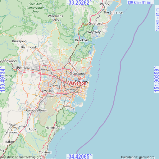
Waverton GPS coordinates[2]
33° 50' 19.068" South, 151° 12' 1.656" East
| Map corner | latitude | longitude |
|---|---|---|
| Upper-left | -33.25262°, | 150.49734° |
| Center: | -33.83863°, | 151.20046° |
| Lower-right: | -34.42065°, | 151.90359° |
| Map W x H: | 129.9×129.9 km | = 80.7×80.7mi |
| max Lat: | -10.58257° ⇑53.2% North |
| Waverton: | -33.83863° |
| min Lat: | ⇓46.8% South -43.31423° |
| min Long | Waverton | max Long |
| 113.53327° | 151.20046° | 153.61246° |
| W 73.1%⇐ | ⇒26.9% E |
Elevation
Elevation of Waverton is 57 m = 187 ft, and this is 65 m = 213 ft below average elevation for this country.
| Max E: |
1715 m = 5627 ft | 43.1% |
| Avg. | 122 m = 400 ft | |
| Waverton | 57 m = 187 ft | |
Min E: |
-2 m = -7 ft | 56.9% |
See also: Australia elevation on elevation.city.
Geographical zone
Waverton is located in South temperate zone (between Tropic of Capricorn and the Antarctic Circle). Distance of this Southern Tropic circle is 1156.6 km =718.7 mi to North.| Distance of | km | miles | from Waverton |
|---|---|---|---|
| Equator | 3762.5 | 2337.9 | to North |
| Tropic Capricorn | 1156.6 | 718.7 | to North |
| Antarctic Circle | 3638.7 | 2261 | to South |
| South Pole | 6244.6 | 3880.2 | to South |


Nearby cities:
15 places around Waverton: (largest is in red/bold)
• Balmain East
2.2 km =1.4 mi,  198°
198°
• Birchgrove
2.2 km =1.4 mi,  229°
229°
• Crows Nest
1.6 km =1 mi,  12°
12°
• Greenwich
1.6 km =1 mi,  266°
266°
• Kirribilli
1.8 km =1.1 mi,  127°
127°
• Kurraba Point
2.1 km =1.3 mi,  101°
101°
• Lavender Bay
0.9 km =0.6 mi, 130°
• McMahons Point
0.7 km =0.4 mi,  160°
160°
• Milsons Point
1.3 km =0.8 mi, 127°
• Naremburn
2.4 km =1.5 mi,  0°
0°
• Neutral Bay
1.6 km =1 mi,  86°
86°
• North Sydney
0.6 km =0.4 mi, 93°
• Northwood
2.2 km =1.4 mi,  300°
300°
• St Leonards
1.7 km =1.1 mi,  353°
353°
• Wollstonecraft
1.2 km =0.7 mi, 303°
Sources, notices
• [Note1] Compared only with cities in Australia existing in our database
• [Src1] Map data: © OpenStreetMap contributors (CC-BY-SA)
• [Src2] Other city data from geonames.org with taken over terms of usage.
• [Src3] Geographical zone / Annual Mean Temperature by Robert A. Rohde @ Wikipedia
