Balmain East geodata
Balmain East (New South Wales) is a section of populated place; located in Australia in Australia/Sydney (GMT+11) time zone. With population of 1,879 people, there are 2986 cities with bigger population in this country. Compared to other cities in Australia, 54% of cities are located further ↑North; 72.8% of cities are located further ←West and 58.4% of cities have higher elevation than Balmain East. Note1


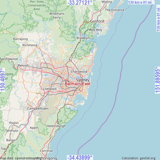
Balmain East GPS coordinates[2]
33° 51' 25.56" South, 151° 11' 34.152" East
| Map corner | latitude | longitude |
|---|---|---|
| Upper-left | -33.27121°, | 150.4897° |
| Center: | -33.8571°, | 151.19282° |
| Lower-right: | -34.43899°, | 151.89595° |
| Map W x H: | 129.8×129.8 km | = 80.7×80.7mi |
| max Lat: | -10.58257° ⇑54% North |
| Balmain East: | -33.8571° |
| min Lat: | ⇓46% South -43.31423° |
| min Long | Balmain East | max Long |
| 113.53327° | 151.19282° | 153.61246° |
| W 72.8%⇐ | ⇒27.2% E |
Elevation
Elevation of Balmain East is 34 m = 112 ft, and this is 88 m = 289 ft below average elevation for this country.
| Max E: |
1715 m = 5627 ft | 58.4% |
| Avg. | 122 m = 400 ft | |
| Balmain East | 34 m = 112 ft | |
Min E: |
-2 m = -7 ft | 41.6% |
See also: Australia elevation on elevation.city.
Geographical zone
Balmain East is located in South temperate zone (between Tropic of Capricorn and the Antarctic Circle). Distance of this Southern Tropic circle is 1158.6 km =719.9 mi to North.| Distance of | km | miles | from Balmain East |
|---|---|---|---|
| Equator | 3764.6 | 2339.2 | to North |
| Tropic Capricorn | 1158.6 | 719.9 | to North |
| Antarctic Circle | 3636.6 | 2259.7 | to South |
| South Pole | 6242.5 | 3878.9 | to South |


Nearby cities:
15 places around Balmain East: (largest is in red/bold)
• Balmain
0.9 km =0.6 mi,  286°
286°
• Birchgrove
1.1 km =0.7 mi,  302°
302°
• Greenwich
2.2 km =1.4 mi,  335°
335°
• Lavender Bay
2 km =1.2 mi,  42°
42°
• McMahons Point
1.7 km =1.1 mi,  34°
34°
• Millers Point
1.1 km =0.7 mi,  104°
104°
• Milsons Point
2.2 km =1.4 mi,  55°
55°
• North Sydney
2.4 km =1.5 mi, 33°
• Pyrmont
1.4 km =0.9 mi,  175°
175°
• Rozelle
2.1 km =1.3 mi,  256°
256°
• Sydney
1.8 km =1.1 mi,  131°
131°
• Sydney Central Business District
1.6 km =1 mi,  121°
121°
• The Rocks
1.4 km =0.9 mi, 99°
• Ultimo
2.3 km =1.4 mi,  169°
169°
• Waverton
2.2 km =1.4 mi,  18°
18°
Sources, notices
• [Note1] Compared only with cities in Australia existing in our database
• [Src1] Map data: © OpenStreetMap contributors (CC-BY-SA)
• [Src2] Other city data from geonames.org with taken over terms of usage.
• [Src3] Geographical zone / Annual Mean Temperature by Robert A. Rohde @ Wikipedia
