Naremburn geodata
Naremburn (New South Wales) is a section of populated place; located in Australia in Australia/Sydney (GMT+11) time zone. With population of 5,772 people, there are 1268 cities with bigger population in this country. Compared to other cities in Australia, 52.5% of cities are located further ↑North; 73.2% of cities are located further ←West and 62.1% of cities have lower elevation than Naremburn. Note1


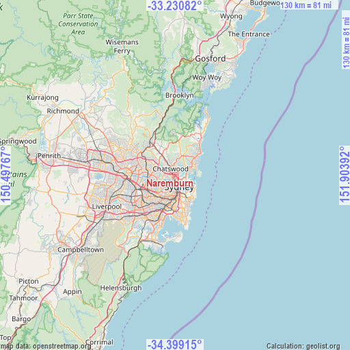
Naremburn GPS coordinates[2]
33° 49' 1.128" South, 151° 12' 2.844" East
| Map corner | latitude | longitude |
|---|---|---|
| Upper-left | -33.23082°, | 150.49767° |
| Center: | -33.81698°, | 151.20079° |
| Lower-right: | -34.39915°, | 151.90392° |
| Map W x H: | 129.9×129.9 km | = 80.7×80.7mi |
| max Lat: | -10.58257° ⇑52.5% North |
| Naremburn: | -33.81698° |
| min Lat: | ⇓47.5% South -43.31423° |
| min Long | Naremburn | max Long |
| 113.53327° | 151.20079° | 153.61246° |
| W 73.2%⇐ | ⇒26.8% E |
Elevation
Elevation of Naremburn is 70 m = 230 ft, and this is 52 m = 171 ft below average elevation for this country.
| Max E: |
1715 m = 5627 ft | 37.9% |
| Avg. | 122 m = 400 ft | |
| Naremburn | 70 m = 230 ft | |
Min E: |
-2 m = -7 ft | 62.1% |
See also: Australia elevation on elevation.city.
Geographical zone
Naremburn is located in South temperate zone (between Tropic of Capricorn and the Antarctic Circle). Distance of this Southern Tropic circle is 1154.2 km =717.2 mi to North.| Distance of | km | miles | from Naremburn |
|---|---|---|---|
| Equator | 3760.1 | 2336.4 | to North |
| Tropic Capricorn | 1154.2 | 717.2 | to North |
| Antarctic Circle | 3641.1 | 2262.5 | to South |
| South Pole | 6247 | 3881.7 | to South |


Nearby cities:
15 places around Naremburn: (largest is in red/bold)
• Artarmon
1.6 km =1 mi,  271°
271°
• Cammeray
1.5 km =0.9 mi,  108°
108°
• Castlecrag
2.8 km =1.7 mi,  47°
47°
• Chatswood
2.5 km =1.6 mi,  319°
319°
• Cremorne
2.6 km =1.6 mi, 114°
• Crows Nest
0.9 km =0.6 mi,  161°
161°
• North Sydney
2.5 km =1.6 mi,  166°
166°
• North Willoughby
2.4 km =1.5 mi,  359°
359°
• Northbridge
1.6 km =1 mi,  74°
74°
• Northwood
2.3 km =1.4 mi,  234°
234°
• St Leonards
0.8 km =0.5 mi,  197°
197°
• Waverton
2.4 km =1.5 mi,  180°
180°
• Willoughby
1.3 km =0.8 mi,  354°
354°
• Willoughby East
2.1 km =1.3 mi,  11°
11°
• Wollstonecraft
2 km =1.2 mi,  209°
209°
Sources, notices
• [Note1] Compared only with cities in Australia existing in our database
• [Src1] Map data: © OpenStreetMap contributors (CC-BY-SA)
• [Src2] Other city data from geonames.org with taken over terms of usage.
• [Src3] Geographical zone / Annual Mean Temperature by Robert A. Rohde @ Wikipedia
