Wallington geodata
Wallington (Victoria) is a populated place; located in Australia in Australia/Melbourne (GMT+11) time zone. With population of 1,361 people, there are 3404 cities with bigger population in this country. Compared to other cities in Australia, 94.3% of cities are located further ↑North; 70.2% of cities are located further →East and 55.2% of cities have higher elevation than Wallington. Note1


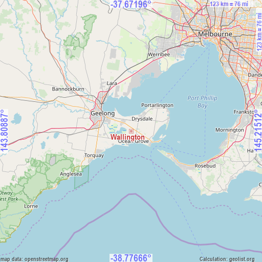
Wallington GPS coordinates[2]
38° 13' 35.076" South, 144° 30' 43.164" East
| Map corner | latitude | longitude |
|---|---|---|
| Upper-left | -37.67196°, | 143.80887° |
| Center: | -38.22641°, | 144.51199° |
| Lower-right: | -38.77666°, | 145.21512° |
| Map W x H: | 122.8×122.8 km | = 76.3×76.3mi |
| max Lat: | -10.58257° ⇑94.3% North |
| Wallington: | -38.22641° |
| min Lat: | ⇓5.7% South -43.31423° |
| min Long | Wallington | max Long |
| 113.53327° | 144.51199° | 153.61246° |
| W 29.8%⇐ | ⇒70.2% E |
Elevation
Elevation of Wallington is 38 m = 125 ft, and this is 84 m = 276 ft below average elevation for this country.
| Max E: |
1715 m = 5627 ft | 55.2% |
| Avg. | 122 m = 400 ft | |
| Wallington | 38 m = 125 ft | |
Min E: |
-2 m = -7 ft | 44.8% |
See also: Australia elevation on elevation.city.
Geographical zone
Wallington is located in South temperate zone (between Tropic of Capricorn and the Antarctic Circle). Distance of this Southern Tropic circle is 1644.5 km =1021.8 mi to North.| Distance of | km | miles | from Wallington |
|---|---|---|---|
| Equator | 4250.4 | 2641.1 | to North |
| Tropic Capricorn | 1644.5 | 1021.8 | to North |
| Antarctic Circle | 3150.8 | 1957.8 | to South |
| South Pole | 5756.7 | 3577 | to South |


Nearby cities:
15 places around Wallington: (largest is in red/bold)
• Armstrong Creek
12.1 km =7.5 mi,  267°
267°
• Barwon Heads
5.7 km =3.5 mi,  200°
200°
• Breakwater
13.6 km =8.5 mi,  292°
292°
• Clifton Springs
8.6 km =5.3 mi,  25°
25°
• Connewarre
10.8 km =6.7 mi,  245°
245°
• Drysdale
7.9 km =4.9 mi,  40°
40°
• Leopold
5.6 km =3.5 mi,  316°
316°
• Moolap
8.4 km =5.2 mi,  304°
304°
• Newcomb
12.3 km =7.6 mi, 303°
• Ocean Grove
3.5 km =2.2 mi,  169°
169°
• Point Lonsdale
10.6 km =6.6 mi,  125°
125°
• Queenscliff
13.9 km =8.6 mi,  109°
109°
• St Albans Park
11.3 km =7 mi, 292°
• Thomson
13.2 km =8.2 mi, 298°
• Whittington
11.6 km =7.2 mi, 296°
Sources, notices
• [Note1] Compared only with cities in Australia existing in our database
• [Src1] Map data: © OpenStreetMap contributors (CC-BY-SA)
• [Src2] Other city data from geonames.org with taken over terms of usage.
• [Src3] Geographical zone / Annual Mean Temperature by Robert A. Rohde @ Wikipedia
