Queenscliff geodata
Queenscliff (Victoria) is a populated place; located in Australia in Australia/Melbourne (GMT+11) time zone. With population of 1,239 people, there are 3527 cities with bigger population in this country. Compared to other cities in Australia, 94.6% of cities are located further ↑North; 69.7% of cities are located further →East and 76.1% of cities have higher elevation than Queenscliff. Note1


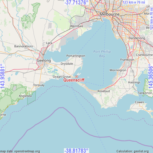
Queenscliff GPS coordinates[2]
38° 16' 4.404" South, 144° 39' 42.948" East
| Map corner | latitude | longitude |
|---|---|---|
| Upper-left | -37.71376°, | 143.95881° |
| Center: | -38.26789°, | 144.66193° |
| Lower-right: | -38.81783°, | 145.36506° |
| Map W x H: | 122.8×122.8 km | = 76.3×76.3mi |
| max Lat: | -10.58257° ⇑94.6% North |
| Queenscliff: | -38.26789° |
| min Lat: | ⇓5.4% South -43.31423° |
| min Long | Queenscliff | max Long |
| 113.53327° | 144.66193° | 153.61246° |
| W 30.3%⇐ | ⇒69.7% E |
Elevation
Elevation of Queenscliff is 18 m = 59 ft, and this is 104 m = 341 ft below average elevation for this country.
| Max E: |
1715 m = 5627 ft | 76.1% |
| Avg. | 122 m = 400 ft | |
| Queenscliff | 18 m = 59 ft | |
Min E: |
-2 m = -7 ft | 23.9% |
See also: Australia elevation on elevation.city.
Geographical zone
Queenscliff is located in South temperate zone (between Tropic of Capricorn and the Antarctic Circle). Distance of this Southern Tropic circle is 1649.1 km =1024.7 mi to North.| Distance of | km | miles | from Queenscliff |
|---|---|---|---|
| Equator | 4255 | 2643.9 | to North |
| Tropic Capricorn | 1649.1 | 1024.7 | to North |
| Antarctic Circle | 3146.2 | 1955 | to South |
| South Pole | 5752.1 | 3574.2 | to South |


Nearby cities:
15 places around Queenscliff: (largest is in red/bold)
• Barwon Heads
15.2 km =9.4 mi,  267°
267°
• Blairgowrie
14.6 km =9.1 mi,  135°
135°
• Clifton Springs
15.5 km =9.6 mi,  322°
322°
• Drysdale
13.3 km =8.3 mi, 322°
• Indented Head
14.6 km =9.1 mi,  17°
17°
• Leopold
19 km =11.8 mi,  297°
297°
• Ocean Grove
12.5 km =7.8 mi,  275°
275°
• Point Lonsdale
4.7 km =2.9 mi,  251°
251°
• Portarlington
17 km =10.6 mi,  358°
358°
• Rye
18.5 km =11.5 mi,  134°
134°
• Saint Andrews Beach
21.6 km =13.4 mi, 138°
• Saint Leonards
11.9 km =7.4 mi, 24°
• Sorrento
10.6 km =6.6 mi, 139°
• Tootgarook
20.5 km =12.7 mi, 126°
• Wallington
13.9 km =8.6 mi,  289°
289°
Sources, notices
• [Note1] Compared only with cities in Australia existing in our database
• [Src1] Map data: © OpenStreetMap contributors (CC-BY-SA)
• [Src2] Other city data from geonames.org with taken over terms of usage.
• [Src3] Geographical zone / Annual Mean Temperature by Robert A. Rohde @ Wikipedia
