Upper Lansdowne geodata
Upper Lansdowne (New South Wales) is a populated place; located in Australia in Australia/Sydney (GMT+11) time zone. With population of 555 people, there are 4690 cities with bigger population in this country. Compared to other cities in Australia, 68.9% of cities are located further ↓South; 84.4% of cities are located further ←West and 65.3% of cities have lower elevation than Upper Lansdowne. Note1


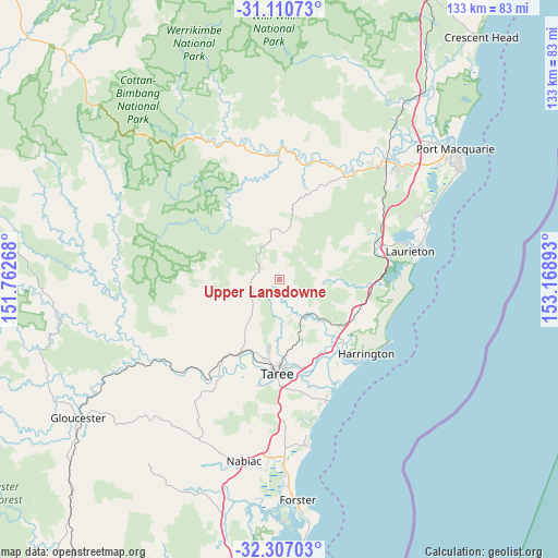
Upper Lansdowne GPS coordinates[2]
31° 42' 38.916" South, 152° 27' 56.88" East
| Map corner | latitude | longitude |
|---|---|---|
| Upper-left | -31.11073°, | 151.76268° |
| Center: | -31.71081°, | 152.4658° |
| Lower-right: | -32.30703°, | 153.16893° |
| Map W x H: | 133×133 km | = 82.6×82.6mi |
| max Lat: | -10.58257° ⇑31.1% North |
| Upper Lansdowne: | -31.71081° |
| min Lat: | ⇓68.9% South -43.31423° |
| min Long | Upper Lansdowne | max Long |
| 113.53327° | 152.4658° | 153.61246° |
| W 84.4%⇐ | ⇒15.6% E |
Elevation
Elevation of Upper Lansdowne is 81 m = 266 ft, and this is 41 m = 135 ft below average elevation for this country.
| Max E: |
1715 m = 5627 ft | 34.7% |
| Avg. | 122 m = 400 ft | |
| Upper Lansdowne | 81 m = 266 ft | |
Min E: |
-2 m = -7 ft | 65.3% |
See also: Australia elevation on elevation.city.
Geographical zone
Upper Lansdowne is located in South temperate zone (between Tropic of Capricorn and the Antarctic Circle). Distance of this Southern Tropic circle is 920 km =571.7 mi to North.| Distance of | km | miles | from Upper Lansdowne |
|---|---|---|---|
| Equator | 3525.9 | 2190.9 | to North |
| Tropic Capricorn | 920 | 571.7 | to North |
| Antarctic Circle | 3875.3 | 2408 | to South |
| South Pole | 6481.2 | 4027.2 | to South |


Nearby cities:
15 places around Upper Lansdowne: (largest is in red/bold)
• Camden Haven
32 km =19.9 mi,  76°
76°
• Coopernook
18.8 km =11.7 mi,  132°
132°
• Cundletown
21 km =13 mi,  165°
165°
• Harrington
26.5 km =16.5 mi,  136°
136°
• Kendall
24.1 km =15 mi,  68°
68°
• Kew
26 km =16.2 mi, 71°
• Lakewood
29 km =18 mi, 72°
• Lansdowne
10.3 km =6.4 mi, 140°
• North Haven
33.9 km =21.1 mi, 75°
• Old Bar
31 km =19.3 mi,  158°
158°
• Taree
22.3 km =13.9 mi,  182°
182°
• Tinonee
25.5 km =15.8 mi,  190°
190°
• Wallabi Point
33.1 km =20.6 mi, 162°
• West Haven
31.2 km =19.4 mi, 74°
• Wingham
19.6 km =12.2 mi,  207°
207°
Sources, notices
• [Note1] Compared only with cities in Australia existing in our database
• [Src1] Map data: © OpenStreetMap contributors (CC-BY-SA)
• [Src2] Other city data from geonames.org with taken over terms of usage.
• [Src3] Geographical zone / Annual Mean Temperature by Robert A. Rohde @ Wikipedia
